This might seem like a repeat of the circumstances which led to the hostile take-over of the Confederated Villages of the Lisjan, INC.: A well-known non-profit organization with dubious claims of tribal sovereignty, and a lack of transparency which was suspended as a corporation by the California Franchise Tax Board for failure to pay taxes and/or file required financial documents.
The fact that Sogorea Te Land Trust is subject to a California Franchise Tax Board Tax Lien was discovered by a Lien Notice filed in Alameda County, on 8/23/2022, as Instrument #2022146941.
It’s unclear if Sogorea Te Land Trust’s Tax Exempt Status will be Revoked, or if the corporation itself will be Suspended by the California Secretary of State (like the Confederated Villages of the Lisjan, INC. was;) but we will continue to provide you with updates as this situation evolves.
In the meantime–if you actually care about whether or not the Land Trust you support (like Sogorea Te Land Trust) adhere to ethical standards, and sound fiduciary conduct, we recommend checking the Land Trust Accreditation Commission’s Website, and searching for the land trust you support.
[Spoiler alert: Sogorea Te Land Trust is not an accredited land trust.]
I read some stuff about what was happening at Wood Street Village, and I wanted to see for myself if it was true. There was an open call for mutual aid, for observers. Reports indicated that removal crews were coming very early in the morning, in an attempt to tow vehicles people were living in, and destroy their property. I read that these city crews were coming as early as 7:00 am to do this, and that it was contrary to a commitment made to place people into other housing, before destroying or removing their current residences.
Some of these articles used words like “cordoned off”, “prevent access by media”. So, I had to see what was happening.
Because this “homeless encampment” has a larger population than many of the places people lovingly refer to as “Pioneer” or “Boom Towns”. In fact, I would argue that these villages are Boom Towns. That the Boom is the disconnect costs and wages, the inequality or unavailability of a continuum of care, a focus on property, and property owners instead of the people involved in all of this transactional “care”.
Because housing is a human right, even though it isn’t a right protected by the law, yet. But the right to due process, protections from illegal search and seizure, and more, are protected. And I definitely knew there actually was some kind of process for relocation. I had to know more.
So, in the morning (approx. 0700), I arrived with some coffee and mini-muffins (cause, I don’t show up empty-handed anymore), and checked in with my initial point of contact to let them know I was there to, like, observe, I-don’t-know-what? But there was a call for mutual aid to observe, so, I’m here, in that car, over there. Then I just chilled in my car for a couple of hours until everyone else started showing up.
For the record, I wasn’t really sure what to tell people when they asked who I was with. Because I was just answering a call from a friend for observers. So I’m just here to see. But I was in contact with people who actually lived there. And I was given confirmation of some of the factual things about notices and times that made the basis of everything I’d been hearing on social media.
What am I here to see? I don’t know; but I’m here to see it. The only thing I represented, feasibly, was the Alameda Native History Project on a Mission of Mutual Aid; Objective: Observe & Report.
06:59 A.M. at Wood Street Village, Oakland, California, at Sunrise
When I arrived there was no one else here, yet. Oakland Public Works employees showed up with a Bulldozer, that they parked in the pictures you see below. Then another truck carrying signage showed up shortly after. They hung around until about 8:00 A.M., when they started closing this section of Wood Street off to use the heavy equipment.
0742 Towards 26th Street0742 Towards Grand Street
Just before 8:00 A.M. the signage was starting to go up. You can see three pictures below of and OPW employee offloading signage from a pick-up truck.
0756 Oakland Public Works Employee Offloading Signs in front of Wood Street Village0756 OPW Employee Offloading Cones and Signs0756 OPW Employee Setting Up Safety Signs, Closing Off Road to Through Traffic
Oakland Police Department showed up briefly; then left to respond to a call within three minutes.
0833 Oakland Police Department SUV Arrives and Leaves Within A Couple Minutes
Soon, more OPW vehicles began arriving, and marking off larger sections of Wood Street for staging. An OPD Parking Tech, and “Civilian Technician” arrived, as well as a Special Assistant to Oakland Mayor, Alexander Evans. Evans was unable to comment as he was there to observe, as well.
0920 Oakland Police Arrives with what looks like Parking Technician, Uniformed OPD “Civilian Technician” also appears.
There was a photographer who was also on-site, named Olivia. Hopefully we get to see her work, ’cause I know she actually went inside and talked to people. So there might be some interviews, and personal stories available.
I spent a long time talking with Daniel Cooper, the City of Oakland Homelessness Administrator, who was in charge of this site. I need to tell you this man has a Master’s of Public Health degree, and brings the concept of the “continuum of care” to the work he’s doing. I know people are really looking at the City of Oakland, and City Employees as the enemy. But, I honestly have never heard the kind of language that Daniel Cooper was using to acknowledge the situation here at Wood Street, and in Oakland, in General.
Like recognizing and naming the role racism has played in creating a situation where a majority of Oakland’s homeless population is Black. How racism creates the conditions for Black people to become homeless more often, and robs them of the opportunity or ability to become housed. And that this system robs everyone of their humanity, but that it’s just because of prejudice and a systemic racism that the people who are most adversely affected are Black and Brown People, Indigenous People, and People of Color because they’re not white; and this system was created to perpetuate the illusion of White Exceptionalism, White Privilege, and what I have no other words for than Racial Nepotism.
Daniel Cooper has a compelling back story that he shared freely. About how he grew up, to even get into one of the best colleges on the East Coast, and the commitment and sacrifices he had to make to finish his degree. You should listen to him speak about these experiences, because they are so relevant to the work he’s doing here, in Oakland. The candor and earnestness of his truth is undeniable.
If you get the chance, I think you should talk to him. Because he has a lot of knowledge and wisdom to drop on us about this subject that we’re only talking about on NPR. But he’s here to do it. He knows how to do it. As someone who’s come in from a completely different state, he doesn’t have the same political allegiances or baggage that any of the former administrators had.
And he has a message: Daniel Cooper vehemently wants us to know that the people we need to be haranguing are our Alameda County Supervisors, and the Alameda County Health Official; who can do things to help fill the gaps of City budgets to fund programs, and create laws and policies which don’t just focus on property, and cleaning debris, but focus on the actual people impacted by these laws and policies. And the people problems, obstacles, and traps, that create the debris and property issues that everyone wants to focus on instead.
Daniel Cooper told me how he personally confirmed availability of rooms and R.V. parking space for relocation himself; on his own time. He has the receipts. He can show you the pictures on his phone from when he went to these places himself to guarantee the availability of these locations. He didn’t have to do it. He could have just lied about it like all the politicians and bureaucrats past. But he did. And that really shows that this man gives a fuck. That he’s actually focused on the continuum of care.
And, I think people should start asking him, a Public Health Expert, what we need to be doing to help him help the City’s Homeless Population. Because, at the end of the day, he’s still just one man, in one position. But the experience and expertise that he brings to this city are something that we should be supporting whole-heartedly.
That means telling the Alameda County Board of Supervisors to give money to cities to help augment the services that Alameda County Provides, to fill the gaps, and support a continuum of care. To let the Alameda County Health Officer know that Declaring a Health Emergency will avail Counties with the resources necessary to respond to this situation like an earthquake, or a hurricane, just happened.
We have tools that we are not using because we are too focused on the wrong part of the problem.
For too long the focus has been on property, on trash, on right-of-way issues. The focus really needs to be on human needs, providing care while preserving dignity, long term treatment, long term support, viable re-location, and the availability of well-funded services to affect all of this.
Criminalization does not solve the problem. You can’t create a system designed to marginalize a whole group of people and then blame them for being the victims of your design. That’s just the ultimate abuse.
But how can we change a system if we continuously focus on the areas where we have the least impact? The most superficial benefits?
We can’t solve this problem with red ribbons, photo ops, or by disrupting a couple city council meetings. We need to identify the specific people in charge and keep the pressure on. We need to fight for specific solutions, with measurable outcomes. And we need to listen to the people who are most impacted; the people who actually live here.
If there’s anything that you should take away from all of this; it’s that you have power, too. And you don’t have to physically show up to make a difference. That you can contribute your voice, and advocate for people by simply picking up the phone, often, to call your Alameda County Supervisor and tell them we need more funding for programs to help people, instead of property owners. And to tell the Alameda County Health Officer to declare a Public Health Emergency to adequately address the conditions that people are forced to live in.
We cannot blame the victims for the fact that we are all complicit in not doing what we can to make this world safer and more equitable for all of us. Just as we created the situation people languish in today, we can also create the conditions necessary to alleviate their suffering, and help lift them out of this purgatory.
… These are the last pictures I took before I left at approximately 10:39 a.m., ending a little more of 3.5 hours of observance.
10:35-10:38 AM 00110:35-10:38 AM 00210:35-10:38 AM 00310:35-10:38 AM 00410:35-10:38 AM 00510:35-10:38 AM 00610:35-10:38 AM 00710:35-10:38 AM 008
I want to note that this isn’t about taking pictures of a “homeless camp” or people who are unhoused. I didn’t even go into the village, because I was here to watch the people in uniform, and to document their activity. Please respect the people at Wood Street Village, by using compassion, and recognizing that this is their home. Please ask for permission before you enter their space; and don’t if they say no. Ask if someone even wants to talk to you. Respect their right to privacy, and to be left alone. The right to quiet enjoyment is truly one of the most basic rights housed people take for granted; and the first right people lose when they are forced out here.
If you want to find out what you can do to help during this process, hit up Daniel Cooper. He can put you in touch with one of the many organizations involved in advocacy for Wood Street Village, and other places with people that aren’t getting as much attention, but need help, too.
You can also email us at Collab@AlamedaNativeHistoryProject.com to add your organization or contact information to this page, as I’m not including anyone’s personal info without them opting in.
Alameda County Board of Supervisors Website Funding for Cities, More services for the County – Literally complain to your County Supervisor often enough they will remember your name.
Alameda County Public Health Department Phone Directory Encourage the declaration of a Public Health Emergency to have access to resources needed to meaningfully address what is a legitimate public health emergency that’s affecting both people, and the environment.
It was only supposed to be a visit. But I could not refuse the opportunity to stay, and answer questions about Native American stuff and History from a bunch of school children.
The lecturing part is kind of difficult, but Q & A is lit. The Alameda Native History Project supports alternative forms & modes of education, such as active, inquiry-based learning. As such, it is more natural to do something like introduce the exhibit and facilitate learning through the learner’s inquiry about specific objects, observations, scenarios, and problems.
In fact, the Alameda Native History Project is an example of the effectiveness of inquiry-based learning; and what a dedicated, resourceful learner can do on no budget, independently of any other organization or institution.
Overall, the aims and goals of this organization is to create a new, more accurate, and nuanced, narrative regarding the Indigenous History of the San Francisco Bay Area. And to do this by using science, and imagination, to re-capture something that is often referred to as “lost”, and “immemorial”.
To which I say: we haven’t even begun to interpret the artifacts left behind by our ancestors, and held in Universities, Museums, and private collections. Indigenous people are now, and have always been, the most well-qualified, and best suited to interpret our own history, and artifacts.
…
I recently spoke with someone from the Martinez Historical Society over the phone, and they invited me to come and see their museum, and talk about their collection, and what might be available and relevant to Native American History in the San Francisco Bay Area. Our conversation was nice; and it sounded like they had an archive which was well put together. So I decided to drop by sometime.
On a recent Tuesday (14 June 2022,) I found myself in the City of Martinez, with my contract work finished, and the Borland House (aka “Martinez Museum) about to open. This was fortuitous, because the museum is only open on Tuesdays, Thursdays, and Saturdays, from 11:00 am, to 3:00 pm–except holidays.
When I reached the door steps of the Borland House, I called out, and introduced myself, to Mary, (I think,) who was just entering the front door. I found out Mary works for the museum when we introduced ourselves, inside. Mary set me up with an explanation of the self guided tour; and I signed the guest book, then entered the first room.
The first room was dedicated to the “The Native Americans of Martinez”; and to the Ranching Period, right after the Rancheria Period. With a really interesting focus on the history of Alhambra, and Fernandez Valleys.
The room was well-lit, and had a lot of space, even though there were: three large exhibit cases; an old cash register; a side-saddle, on a big mount; a complete and bonafide cowboy get-up; two flags (50-star and California bear); branding irons; a hitching post; a flat-iron stove, with the english flat iron… and something else in the corner by the window between the case and the get-up I can’t recall….
Now that I think about it, there’s a Cowboys and Indians Theme here.
There’s an implication of us, and them; before and after.
“Native Americans used to be here; but then we came; they left; and we built ranches (agriculture), infrastructure, and industry.”
I think it’s really important for you to know, that–from an Indigenous Perspective: The Mexican Rancheria and California Ranch Periods can be seen as one long Ranch Period, punctuated by violent foreigners with cows, horses, guns, and hats.
In fact, one of the primary areas of conflict were cows on tribal territory, without permission or payment, eating the primary food stock of not just one tribal group, but the primary cereal stock of all of the tribal groups in the region. Nuances include: the plants weren’t even ready to eat yet; and–when we complained–the conquistadors would raid our villages.
The Spanish and Mexican Era in California History is often miss-understood, and poorly interpreted, when it comes to the Indigenous experience during this time. And questions like “Where did all the ‘Indians’ go?” are a by-product of this lack of knowledge, and perspective. Real Indigenous California History can explain what happened, and fill in the gaps of the vague generalizations found in most textbooks, and taught by most universities and institutions today.
…
The longer I stayed at the museum, and engaged in the exchange of knowledge and experience, the more I came to understand the nature of the misunderstanding and, therefore, misrepresentation of Native American History outside of institutions like Universities, and specialized Research Projects, like the Alameda Native History Project.
After all, local historical societies and museums are run by community members. The Borland House/Martinez Museum is an example of a local historical society which has very personal, and direct ties, to the living history of the community it serves. This is evidenced by Sandy’s family heirlooms, from the family ranch, in Fernandez Valley appearing in the Ranch Life Exhibit.
But these histories are not as dichotomous as one would assume.
In the San Francisco Bay Area, many Ohlone, Karkin, and Saclanes people became ranchers during what was largely considered the Ranch Period, inclusively. Because white people and white history–which is what is taught in schools, and most museums and other institutions–are unable to distinguish between different shades of brown: the movement of Indigenous people, through (and into) the Spanish and Mexican population went largely unnoticed. In the eyes of white history, we simply disappeared, ceased to be seen within the sea of brown faces laboring in fields, and breaking horses on ranches all throughout California. My great-grandpa was a Numu Cowboy.
As someone who was born and raised in America; who was adopted out of my tribe, and raised by white people; I understand the concept of, and experience multiple forms of otherness, in a very unique way. And I can recognize we have all been indoctrinated into believing the white excellence narrative of the founding of America at some time or another. And the belief that success only comes from dominance, and exploitation. This is the class structure that was created by these foreigners. People who aren’t even from here. These old, dead, christian, white supremacist, terrorist, European war criminals–on boats. Who are called heroes, pioneers, and innovators, today.
In reality, these people were riding the high of a religious fervor, following the heretical concept that God promised white people heaven on earth; a Zion in wait–in the form of “The Americas”–and that it was God’s will to purge this land of anyone but white christian fundamentalists (aka “God’s children”.)
The concept is called “Manifest Destiny”, and it was first heard in 1845. But these were just words used to name a belief that made it possible to justify so much harm, so quickly, to so many people; and to relieve white people of their individual guilt, and responsibility. After all, their God told them to massacre women, and children; spread disease through contaminated blankets; and destroy the Buffalo, and every other living creature on Earth. Why should they be responsible for their actions, when it was God’s Will to kill every heathen who couldn’t be saved, and every savage who couldn’t be tamed?
The true cost, and horrors of the Indian Wars have been largely unaccounted for; and such barbaric concerns were certainly not spoken of in a civilised Victorian society. The newspaper articles concerning “Injun”, “Indian”, “Red Man”, “Savage” are just as offending as you think they would be. Except, the articles about military engagements and victories never mention the war crimes. Which is strange, considering how much shit they were talking about everything else.
But this is still a narrative that centers colonization, and the colonizer. Any time you de-center the colonizer from Indigenous History, you only have Indigenous History.
The problem with white history is that it’s narcissistic. White history only wants to see itself reflected in the story of other people. White history does not want to learn the story of those people. Because the story of those people ended when white people conquered them.
…
In the first room, Mary was talking with another woman, who I would find out is named Sandy. Sandy is a volunteer docent. She also has some pretty cool family heirlooms in the ranch displays. However, she is not very familiar with the Native American Exhibit. So, Mary and Sandy were going over the names on the maps, and the artifacts.
Unbeknownst to me, Mary, Sandy–and Maris, who I will meet in a minute–are all getting ready to host 40 school children for guided tours through the Borland House.
So, instead of trying to crowd around the Native American exhibit, I shunt off to the kitchenware, and the (very nice) bobcat fur. I look at the pictures of the men on the wall, and the wine press and grapes, and nice under-stairwell niche, that’s been turned into an exhibit about the “First Lady of Martinez”.
But I can still hear someone trying to work out the names on the maps. “Car-kwee-in? Yeah….” The not-so-sure voice said from behind.
“It’s Car-ken, like K-A-R-K-I-N.” I said, “That’s the name of the people who lived here.”
They apologized; and switched to the proper pronunciation. Which was cool. And then they started working identifying the objects in the case.
Most of the items were found in the hills behind the John Muir House. Beautiful arrowheads of all forms, shell necklace jewelry I’ve only seen in archaeological texts, in very good condition, right in front of me. Close enough to wonder at the adhesives developed to construct complex objects that require durability, like rattles, fans, and regalia.
There were strands of heishi beads in clamshells, and abalone pendants that look like they’re straight out of the book.
Someone asked if these beads and shells were treated as cash. And I just saw the opportunity to shift the paradigm a little. I know, I totally butt in, and man-splained. But, I was actually there specifically for the purpose of visiting local Bay Area Historical Societies, and seeing how they chose to curate Native American History, to find new sources of information, and creative methods and examples of curation and exhibit design.
And I thought what a shame it would be to have such a nice exhibit without the proper interpretation.
Plus, despite having the visual aids and information provided by the East Bay Regional Park District’s Ohlone Curriculum, these people were still having problems putting it all together. And I realized, maybe for the first time: that this isn’t their fault. That these people actually wanted to know more, and had taken the time, and done the work to find the best information available today.
It was clear the amount of care and reverence that was paid to Native History; and the importance these docents placed on actually learning about all of the exhibits in the local museum they helped curate. They were humble, honest, and willing to learn. And, despite none of us having planned any of this, we found ourselves sharing our mutual understanding of California’s history.
It started with an explanation of the economics of trade in the San Francisco Bay Area; and our (California Natives’) connection to each other all over the state. I outlined some of the more valuable things people traded with, and mentioned that scarcity and distance also played a role in something’s value. We didn’t simply trade shellbeads as money. We traded dug-out canoes, marriage regalia, houses, ceremonial items … and the components to make those items. Sometimes the components were equally as valuable as the finished item itself. I introduced the nuance that not everyone made regalia, or canoes, or arrows, or grew food; that these were specialized objects, created by artisans, and so trade with these artisans was different than trade for subsistence, or goods.
I mentioned the difference between the Tule Canoes, and the Dug-Out Miwok Canoes. We talked about the different language regions, and I helped compare and contrast the information provided by all of the East Bay Regional Park District’s Ohlone Curriculum Maps, providing annotation on the changes in research, and narrative, visualized in each one.
I told them that Miwok was the primary language spoken in Missions, so that’s why everyone thought all the Natives here were Miwok. That, when the Spanish came, we had a difficult choice to make, that we could have either stayed, and capitulated; or we could leave, and try and live our lives in the ways we knew how.
I told them how the people who stayed formed their own groups, and that the struggle became more politicized than a simple struggle of resistance. Because there were indigenous people who had converted and joined the missions, or worked for the conquistadors, or the white “Californios”, who were beginning to trickle in later on. And then there were the indigenous people who still chose to fight, and stay in the valleys and on the shorelines of their ancestors. These people were not united. And all of these groups became locked in a struggle against each other, and against the colonizing population. They were all struggling for power, and influence, and survival, ultimately.
In between there was the Spanish-Mexican War, and then the Mexican-American War; and during all of this, indigenous people slipped through the cracks. No one was really worried about the what Native Americans were doing, until California had been firmly placed in American control; because Indigenous people had effectively been removed from the crusade for land and gold. Colonization. Conquest.
Once the Americans had wrested California from Mexico, any indigenous people who could pass for Mexican or Spanish did; to avoid being rounded up and put into concentration camps called “reservations”. And we continued to live and labor here, virtually unnoticed, dormant, for the next seven or eight generations. Surviving numerous attempts at erasure, genocide, family separations, and government neglect.
I said we are becoming more visible. Like the Muwekma Ohlone Tribe of the San Francisco Bay Area. But it’s not a “comeback”, because we never left.
Then we talked about the fact that there’s not a lot of information on what happened to Native Americans after. But I explained that there is. That the only reason we don’t fully understand these items and their significance is because of a lack of imagination and grasp of metaphor on the part of early archaeologists who thought they were the expert in someone else’s culture.
I told them that people assume Native Americans weren’t engineers, or scientists because they don’t have the ecological background to (a) recognize, or (b) appreciate the fact that Native American civil engineering projects were academic exercises in recreating natural systems with such expertise that white people can’t tell the difference between rivers and creeks, and indigenous designed and constructed regional irrigation systems. That our systems were designed, essentially, to dissolve into the natural world without much as an oil slick on the surface. Because we are not colonizers and we do not attempt to conquer the natural world because we realize we are an integral part of it.
That Native Americans can tell you what happened to us; it’s just that no one listened to us ever, and we honestly still feel some type of way about what happened. [Is happening.] So that’s why we just don’t want to talk about our history so much.
But, if Native Americans were consulted, we would be able to fill in the holes, and be able to identify all of the items in their collections, as well as explain their uses and significance. Just as Mary, Sandy, Marvis, and I did.
And that was when Mary asked if I would mind staying to talk to some school children about everything I just said about the objects in the case, and the fact that Native American People are still here, and alive today.
Honestly, I was really interested in learning what the kids thought about these objects, and what they wanted to know about. This would be a great opportunity to create a kid-friendly narrative for some of my work that other educators can use or build on. Or… at the very least, help me figure out what kinds of labs, workshops or demos would be the most entertaining and the best for generating an organic, student-led discussion, guided by their inquiry.
I was this many years old when I found that’s called “de-centering” the teacher.
Anyway, it was hella fun. And It was really awesome to see these kids get excited to learn about these objects. And I was really happy that someone said something like “we have one have of those at home”, when I was showing them the mortar and pestle, because I got say, “That’s great! What do you make with it at home?” And explain how lots of people use metates, or mortar and pestles, to make their food, and stress how awesome it is that we have something in common. (And it’s even more awesome because it’s food!)
I learned a lot, myself, with the help of the day campers. And I was really just happy to help. It’s been a long time since I stood in front of an interpretive station to make a presentation. And, yeah. This was the beginning of an unofficial collaboration and partnership with the Martinez Historical Society.
Gabriel Duncan, of Alameda Native History Project, showing Martinez Day Campers a mortar and pestle.Looking up to make sure everything’s okay with the second mortar and pestle. … Hearing my mom’s voice yelling at me over the hardwood floors in my head.
…
Over the next month, I would work with the Martinez Historical Society to give them some foam-mounted maps to address their historical and cartographic needs and wants. So, that’s where we’ll pick up in the next article.
On Monday, Amy Wooldridge (Director of Alameda Parks & Recreation Department) replied to our open letter concerning the possibility of Sogorea Te Land Trust being given a portion of Linear Park, in Alameda–at the corner of Main Street and Singleton Avenue.
In our preliminary email, asking whether or not this was true, Wooldridge told us: “The Recreation and Parks Department is working with the Sogorea Té Land Trust and Confederated Villages of Lisjan to develop an agreement regarding a section of tule plants in the Main Street Linear Park between Singleton and Stargell streets…. Sogorea Té Land Trust will take responsibility for maintenance of this area which includes removing weeds and invasive plants…. They will also then have the opportunity to cultivate the tule plants that they use for ceremonial dress, boats, roofing, and baskets.”
Our primary objections were two-fold:
The Confederated Villages of the Lisjan Nation, Inc. is not a tribal government; the City of Alameda is Muwekma Ohlone Territory.
Confederated Villages of the Lisjan Nation, INC.
Muwekma Ohlone Tribe of the San Francisco Bay Area
Less than 5 years old.
Documented existence before 1890. (aka “Time Immemorial”)
Represents 1 family.
Thousands of enrolled tribal members.
Corporation
Federally Recognized as a Tribal Nation*
*The Muwekma Ohlone Tribe of the San Francisco Bay Area is currently fighting to restore their Federal Recognition as a Tribe. Find out how you can help.
The site proposed for management by Sogorea Te Land Trust has been subject to soil and groundwater pollution which was never properly cleaned.
2 x 6,000 gallon gasoline tanks removed in
1 x 550 waste oil tank.
These tanks were leaking gasoline and waste oil into the soil at Main Street, and Singleton Avenue, specifically.
Contaminated soil around tanks were used to back-fill holes made from tank removal.
Contaminated groundwater sprayed on contaminated soil for dust suppression during the entire project.
Existence of Toxic Marsh Crust 4-18 below ground surface.
Water table at 3 feet BGS, drainage ditch at least 4 feet deep.
2021 Groundwater Ambient Monitoring and Assessment report finds Benzene, Naphthalene, and other contaminants in ground water at one of the 26 underground storage tanks within 1,000 feet of proposed land management area.
Specific guidance from Alameda County Healthcare Services requiring review of sufficiency of corrective actions before Land Use may be changed.
It was our impression that the City of Alameda had reached out to Sogorea Te Land Trust in another performative display of “restorative justice” to give indigenous people [toxic] land back.
We found out that this was not the case. Sogorea Te Land Trust was not being given land by the City of Alameda.
“This was simply intended as a short, one-year maintenance agreement that also included and allowed for the Sogorea Te Land Trust to cultivate the plants for non-edible purposes.” Amy Wooldridge told us; adding, “They had reached out to me directly with this interest and since this park is in need of more maintenance, it seemed like a good fit.”
However, after being told about the dubious nature of Sogorea Te Land Trust’s intentions to convey trust land to the Muwekma Ohlone Tribe of the San Francisco Bay Area, and being given credible information regarding the suspected contamination of Linear Park, Amy Wooldridge has told us she intends to “pause” plans for collaboration with Sogorea Te Land Trust, “and will keep the Muwekma [Ohlone] Tribe of the San Francisco Bay Area apprised of anything connected with Indigenous People that I’m involved with here in Alameda.”
This news is a victory for the Muwekma Ohlone Tribe of the San Francisco Bay Area, because the City of Alameda falls within traditional Muwekma Ohlone territory.
This is an excerpt of a letter sent to ARPD’s Amy Wooldridge, the Alameda Recreation and Parks Department Director; as well as City of Alameda Mayor Marilyn Ashcraft, Vice Mayor Malia Vella; and Council Members: Tony Daysog, Trish Herrera Spencer, and John Knox White [who made the original announcement concerning the indigenous land management of property on Main Street, between Stargell and Singleton.]
Hey Amy,
Thanks for getting back to me so quickly. I wanted to address two things.
1. The Confederated Villages of the Lisjan Nation, INC. is not a Tribal Government; it is a nonprofit corporation.
The name of the true Ohlone Tribe of this area is the Muwekma Ohlone Tribe of the San Francisco Bay Area.
Muwekma has been known as “Costanoan”, the “Verona Band”; and they have self-identified as “Yo soy lisjannes” [“Chochenyo Field Notes”, Harrington, 1921]. Additionally, the present-day Muwekma Ohlone Tribe is comprised of all of the known surviving American Indian lineages aboriginal to the San Francisco Bay region who trace their ancestry through the Missions Dolores, Santa Clara, and San Jose; and who were also members of the historic Federally Recognized Verona Band of Alameda County. [Muwekma.org; as well as both their BIA petitions for federal recognition.]
Federal Recognition could help Muwekma in the following ways, as they relate to ARPD, and the City of Alameda’s relationship with CVL:
A Land Base would be established for Muwekma in the Bay Area,
This may include ANAS/FISC Alameda property; and other open space in the City of Alameda.
Land Banks held by agencies like the East Bay Regional Park District will be transferred to Muwekma
Muwekma would be endowed with the Legal Standing required to bring suit for the cessation of excavation, destruction and/or development of Tribal Cultural Resources in the City of Alameda–
And, this might leave ARPD and the City liable, should they irrevocably devote land and resources to a corporation that is not actually a tribal government (please be careful, because we need our Parks and Rec Department; it would suck if they lost funding because it was reappropriated as restitution, or a settlement.)
Theoretically, there should also be a conveyance from Sogorea Te Land Trust to the Muwekma Ohlone Tribe of the San Francisco Bay Area at this point–as Federal Recognition would render the necessity/mission of a land trust to hold land for an unrecognized tribe moot.
Aside from the factual issues with recognizing a corporation less than 5 years old as a Tribal Government; there is the political consideration.
Muwekma is a tribal nation that is trying to regain federal recognition. One of the most crucial elements they must prove in their petition is that Muwekma has existed as a continuous group since the last time they were recognized as a tribe; and that the tribal governance structure has retained its political influence on said group. This has been extremely difficult for them to plead at the level the BIA requires. And several prominent politicians have spoken out against what they believe is an arbitrary and capricious refusal by BIA to reconsider Muwekma’s petition for tribal recognition. [This is on top of previous judicial opinions also in favor of reconsideration.] But, there is another way that Muwekma can regain Tribal Recognition; and that is by an Act of Congress.
However, to affect this action, Muwekma must have a broader political influence beyond its own membership. This means they would have to gain wider public support for their cause, in order to effectively encourage congressional representatives to introduce legislation renewing Muwekma’sTribal Recognition.
I believe that the City of Alameda, and ARPD’s public endorsement of the Confederated Villages of the Lisjan Nation, INC. as an Ohlone tribe is an error which is detrimental to the rights and struggles for recognition and sovereignty of the Muwekma Ohlone Tribe of the San Francisco Bay Area insomuch that it lends false validity to a corporation that is fraudulently portraying itself as a Tribal Nation to benefit a small group of people over the needs of thousands of bonafide Muwekma Ohlone Tribal Members.
It also contributes to the erasure of all of the people whose ancestors were ground up to pave Bay Farm Road; grade former train tracks in Jean Sweeney; and fill marshland around Krusi, and Harrington Parks, among others.
It is for these reasons that I strongly suggest ARPD, and The City, reach out directly to the Muwekma Ohlone Tribe of the San Francisco Bay Area before you consider doing anything else.
2. Ongoing Contamination of Soil and Groundwater At or Near Linear Park (On Main Street, between Singleton and Stargell)
I’m concerned about the most recent Groundwater Ambient Monitoring and Assessment data regarding Benzene and Naphthalene found in ground water samples around this site. These chemicals were found in 2021 data, and no mitigation activities have occurred, as this site is now open and being investigated. It’s reasonable to assume that groundwater contamination is transient, and could affect Linear Park because it has a drainage ditch well below the surface of the surrounding land, including all sites appearing on the map below. This is the same drainage ditch Tule grows in now.
Additionally, I would like to note that Linear Park itself has been subject to contamination from leaking underground storage tanks (UST’s); which contained gasoline, diesel, lubricating oil, waste oil, and other hazardous materials; which released harmful chemicals, including the two listed above (among others), into the soil and groundwater directly upon the property now referred to as Linear Park.
There are also 26 points within 1,000 feet of Linear Park which have been affected by soil and groundwater contamination, much of the land surrounding Linear Park are subject to Land Use Restrictions expressly against digging/excavating, or using groundwater. Some of these Land Use Restrictions prohibit Schools or Housing from being built on those parcels because of the risk to human health (specifically to children.)
Additionally, there is the existence of the Toxic Marsh Crust, which lies 4-18 feet below the surface of any given point on the map presented here, and presents an unknown and unmitigated hazard to any plant or animal for the foreseeable future. For your reference, the highest water level sampled for this area was given at 3 feet below ground surface (BGS); and the drainage ditches are at least four feet deep.
Please find the attached PDF “CLOS_L_2002-01-14.pdf” which is a letter from the Alameda County Healthcare Services Agency, Environmental Services, Environmental Protection, Hazardous Material Specialist Eva Chu, addressed to the City of Alameda. This document details the contamination at the point where the tule grows in Linear Park, at Singleton and Main Street. This letter notes current concentrations of hazardous materials, and examines how the underground storage tanks were removed, and the land treated.
On top of the soil used for backfill being contaminated, polluted groundwater pumped from the site was sprayed onto the soil to suppress dust during work… further contaminating an area that was supposed to be cleaned.
All of this points to:
A strong possibility that the soil and groundwater harbor contaminants dangerous to humans;
The certain necessity to test soil and groundwater in this area to determine its safety.
Furthermore, certain safety plans must be created before digging, trenching, or groundwater may be used. The attached report also states that the corrective action for this parcel must be reviewed if land use changes.
Currently this land is technically wetland and flood mitigation for tidal surges which typically flood this area. The proposed use: to grow plants for food, clothing, and medicine to be consumed, inhaled, smudged with (,etc.); is clearly a much different use[–for human consumption vs. flood mitigation]. Therefore the re-evaluation of these parcels is not just a good idea, it is an enumerated necessity, according to Hazardous Materials Specialist Eva Chu.
Please find the attached “Map Showing Past & Present Contamination in City of Alameda Proposed ‘Indigenous Land Management’ Parcels”
It is for these reasons that I strongly object to letting anyone manage any part of, or consume any thing from Linear Park–at all–until the question of contamination has been thoroughly examined, and competently settled.
Thanks for your attention to these matters. If you have any questions, feel free to reach out to me.
Alameda Native History Project releases a new Alameda Shellmound Map Model to show the capability of Augmented Reality, when it comes to virtual classrooms, and independent & remote learning. And to showcase the direction of education, and uses for technology, as we progress further into the 21st Century.
This map is appropriate for use in a K-12 setting; and represents the Alameda Shellmounds, as seen by N.C. Nelson. [“Shellmounds of the San Francisco Bay Region”, Nelson, 1909] This map model was created by Gabriel Duncan, and it was stylized using Adobe Aero.
Alameda Native History Project is not sponsored by, or receiving money from Adobe. This is not a paid product placement. This is an example of how to use the tools already available to you, for free, to make really cool stuff for your class or presentations.
For more information about this model, or how to get a copy, email the Alameda Native History Project.
The Alameda Native History Project project presents a map of the three Alameda Shellmounds, as seen by N.C. Nelson in 1907, restored and presented in the present-day landscape.
For the first time ever, the Shellmounds of Alameda are being visualized, and presented as a physical, tangible land feature.
The purpose of this map is to:
Acknowledge that Alameda was a place were local Ohlone communities came to bury their loved ones;
Illustrate the large size and scale of shellmounds, in general;
Visualize a theoretical landscape where the Alameda Shellmounds were preserved;
Fill the gaps made by Alameda Museum’s lack of accurate or meaningful information about the First Alamedans: Ohlone People.
Created using derivatives of open-source data, including (but not limited to) USGS, NOAA, USCG, NASA, Google Earth. Analyzed, processed, and produced by the Alameda Native History Project, using open-source software available to anyone with a smart phone, and the most basic computer.
Why did the Alameda Native History Project create these maps?
Necessity
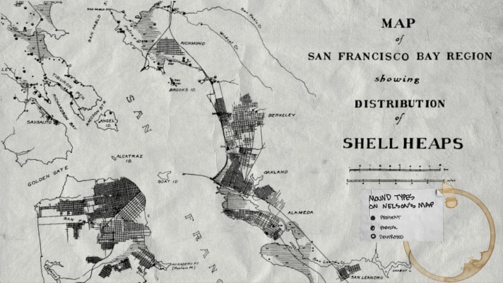
The first map created by the Alameda Native History Project was the geographicaly-conformed (or “geo-conformed”) version of N.C. Nelson’s historic 1909 Map of the San Francisco Bay Region Showing Distribution of Shell Heaps. This 20th Century version of Nelson’s map was painstakingly converted, and conformed, to 21st century Geographic Coordinate Systems.
Geo-conforming Nelson’s map made it possible to accurately plot the coordinates marked on Nelson’s map; and perform Present Day Observations of the Bay Area Shellmounds.
The San Francisco Bay Area Shellmound Map now has over 300 confirmed locations. The accuracy of this map has improved considerably over time; and the research version is now accurate to within 100 feet.
This was because maps like those featured by the Stanford University’s Spatial History Lab were little more than photocopies of the original coastal surveys, with graphic overlays.
While this might be impressive to some, the lack of any real functionality or new information derived from this kind of exercise was underscored when I tried to find/use this information in the context of the Shellmounds of Alameda.
Stanford University, Spatial History Project1909 N.C. Nelson Map of the San Francisco Bay Region Showing Distribution of Shellheaps
This made it necessary to recreate a map of the historic shoreline of the San Francisco Bay Region, and hand-plot more than 300 shellmounds, just so I could view these maps and take screenshots of them to share with you. All in an effort to show you where the Shellmounds of Alameda are.
Clarity
Reproduction of Whitcher’s Survey.
The same geo-conformance process was applied to an historic map of Alameda, which has become the Alameda Museum’s sole reference concerning the shellmounds of Alameda: Imelda Merlin’s “Alameda: A Geographical History”. This book is a Geology Master’s Thesis, by Imelda Merlin, who lived and died in Alameda, California.
The fact that Merlin was an Alameda resident; and that Alameda Museum owns the copyright to the book should be immaterial to the generally dubious nature of a photo-copied map, with hand-drawn notations.
In spite of the fact that Imelda Merlin was a student at the University of California, Berkeley, it appears that the most relevant information created by N.C. Nelson–for the archaeology department of the same university–was avoided altogether by Imelda Merlin in her work.
For the aforementioned reasons, it was determined that Imelda Merlin’s work merited careful scrutiny and interrogation.
Because, at this point, I already had two other sources of location information compiled for the Alameda Native History Project:
1. Public Records Aggregate
Any mention of Alameda Shellmounds in the following archives/libraries/collections:
All references to the Alameda Shellmounds at the Alameda Free Library:
this includes references in the Historic Alameda Newspaper Archives, and the “Alameda Historic Reels”;
as well as Clipping Files, Alameda Historical Society Card Catalog [Defunct];
Library Catalog, and Special Collections.
Online Newspaper Archives, Indexes
Online Finding Aids
Genealogy Websites, National Archive, and More.
References were logged, and copies of the documents were saved. Then the documents were analyzed, information was extracted, and processed to produce an aggregated list of locations of the Alameda Shellmounds–according to explicit references in these sources.
Then the locations were geocoded, and plotted to create a map that … I don’t even know what to call. “Shellmounds Mentioned in the News”?“Historic Shellmounds”?
“Public Records” is not a very attractive label; but it might be the best label for that layer on the Alameda Shellmounds Map. [So, in case you ask “What is the Public Records Layer on the Alameda Shellmounds Map”, now you know.]
2. Nelson’s Map of the SF Bay Region Shellmounds
Like I said, this was the first map I painstakingly recreated. So, therefore, I had the locations Nelson marked within Alameda.
When I analyzed the base map printed in Imelda Merlin’s book, I was able to use these sources to help conform Merlin’s base map with current Geographical Coordinate Systems, so I could plot the positions marked in the Imelda Merlin layer in the Alameda Shellmounds Map.
I used innumerable copies of maps, surveys, photographs, and other visual representations of Alameda, from 1880 to 1910 to help conform the “Whitcher Survey” referenced in Merlin’s Map. I was never able to find a true copy of the “Whitcher Survey”. The survey is not at City Hall–as Merlin’s book states–or in the Alameda Free Library. The Museum did not have it, at last check.
I also looked to see if any map copy provided by the official website of a University, or Government Institution, or the publisher itself, or a credible archive, actually included similar shellmound positions during the time Merlin’s map was created.
TL;DR: they do not. Not even the Land Grant Case Maps, or the legit Combined, Drafted, or Official Coastal Surveys of that time, have even a hint of a shellmound anywhere. (I even tried to find a copy of the coastal survey used in a well-known documentary about the Shellmounds of West Berkeley, but was unable to track down the file before publication.)
However, even though Merlin’s map diverges from the Official Historical Record, she did capture something in her hand-drawn sketch: all of the dots on her map correspond to places where Ohlone graves have been found.
In spite of the fact Merlin calls the First Alamedans “Miwok”–instead of Ohlone. In spite of the fact that Merlin doesn’t even mention the map in the actual narrative (or “text”) of her book. In spite of the fact that the map was published in her thesis (which was then published a few years later, in a book) without any references, or citations–aside from the coast survey base map.
Somehow, she manages to highlight the same places I have located using mentions of Ohlone graves and Native American remains found in historic Alameda newspapers. Many of these discoveries happened decades after the publication of Merlin’s work. …Which could indicate that these discoveries are coincidences, rather than correlations.
It makes sense that the discovery of human remains would be carefully guarded; only mentioned in whispers between Alameda insiders, and related professionals. Certainly, the newspaper would be encourage to leave anything like that out. … At least until the houses were sold.
It’s not hard to have editorial control when real estate companies were the primary revenue sources for local Alameda newspapers. Furthermore, the Redline wars in Alameda were brewing long before residents voted to approve Measure A, in 1973.
In a “closed”, racist, housing economy, where BIPOC are excluded, and declining property values could be caused by even a whisper of non-white interest in a neighborhood: the prevalence of bones underfoot could undermine the appeal of an entire city.
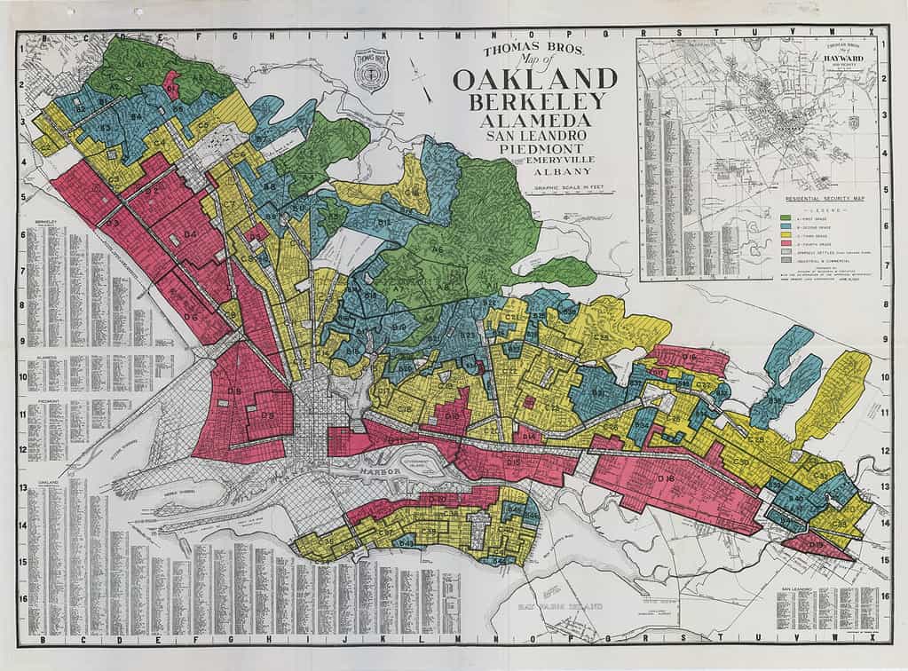
Historic Redline Map showing Oakland, Berkeley, and Alameda
Alameda was probably a place where the surrounding Indigenous communities would come to bury their dead.
When you take into account historic newspaper articles like the one below (from 1893;) and the preponderance of subsequent articles concerning Native American Graves and Remains found, and then plot those locations into their own map, you get a layer of “Remains & Relics Found”.
While it is the Euro-Centric imperative to determine a single point; and explicit boundaries: the size and nature of the shellmounds was as much a mystery to these colonizers as it is to us today. For different reasons though.
Early anthropologists, archaeologists, and ethnologists lacked the imagination necessary to make the logical leaps necessary to recognize the purposefully obscure nature of our infrastructure, or decode the metaphors we left in notes and drawings for our friends.
Because of this, and because white people destroyed as much of our stuff that they possibly could (on purpose [I don’t know why]), we are now–in many cases–left with the remnants of remnants.
Because the records concerning these events, and the mere existence of the massive burial grounds under the City of Alameda, and the cities of the rest of the San Francisco Bay Region have been actively concealed, and suppressed, this story has remained untold.
“Alameda’s Indian Mounds“, published in The San Francisco Examiner, on Sunday, March 26, 1893:
“When the progressive Alamedan decides to build a home of his own on a section of the encinal that have been allotted to him by his favorite real estate dealer…
“He does not order work suspended when the excavators, who have undertaken the task of building his prospective basement, run across a well preserved skeleton or turn up a hideous looking skull.
“He has become used to such things and he knows…
“in all Alameda there is scarcely a square yard of ground that does not harbor the crumbling remains…”
The pieces of the puzzle can still be found.
And so, Nelson’s Map, Merlin’s Map, and the Public Records map were offered as three separate layers of the Alameda Shellmounds Map; so that you may also discover and analyze the similarities and differences between the locations, yourself.
The other layers mentioned, such as “Remains & Relics Found”, and more are also available to view using the layers panel of the Alameda Shellmounds Map.
As our records continue to grow, and new information found, the map and this site continue to grow as well.
Aesthetic & Availability
Let’s face it: no one wants to look at nth generation copies of copies.
I don’t know about you, but I’m tired of trying to squint, and adjust brightness, contrast, and gamma until I can barely almost read the most important part of this chapter….
I want to look at a webmap of the San Francisco Bay Area Shellmounds. I need my experiences to be more interactive, and offer more than an empty citation to a book I can’t even find anymore. I want to see a scan of the book. And read the citation myself.
But even that’s not enough. I find myself getting triggered by the language of these old, dead, white men that I just want to fight.
Most of these narratives are written from an all-white perspective, often using racial slurs, and offensive descriptions. For the past 74 years, the Alameda Museum has furthered the “gentle savage” myth that permeated Victorian Era culture in America. And continues to push the idea that Ohlone people just disappeared from Alameda, and the Bay Area, entirely.
It’s been the same narrative since “time immemorial”. (Even that phrase is from a white-washed narrative meant to pander to a White Gaze that isn’t even a majority anymore.)
California History, when it comes to Indigenous People, is broad, at best. Very little space or effort is given to properly naming, or describing Native Americans, how they looked, where they lived, what they ate….
Most textbooks will even allude to American Indian relationships with White People as something symbiotic; and leave this chapter of history conveniently blank, to make room for the concept of Manifest Destiny.
The history that we are being taught has specifically avoided the policy of indigenous extermination enacted by a California Governor in the late 1800’s; California’s military support of Indian Wars in Oregon in the early 1900’s; or, how Los Angeles stole water rights from Tribal Nations in the Central Valley and has helped to destabilize the California ecosystem, with devastating effects.
We are not taught about this.
We have instead been dazzled by trains, bridges, and pretty houses with gardens, like babies with a ring of keys.
California is the most diverse state in terms of Tribal Nations, with over 300 Indigenous Languages Spoken in California, alone. We are astronomers, conservationists, artists, engineers, doctors, and so much more. Our stories and contributions matter.
Ohlone people still live in the San Francisco Bay Area. The Muwekma Ohlone Tribe of the San Francisco Bay Area could use your help in fighting for federal recognition.
The Native American, Indigenous People that you speak of like they went extinct in the 1800’s; those people are my great-grandparents.
The first step in justice for Indigenous Californians is recognizing us.
This is why it’s important to update the aesthetic of Historical Curation, and Exhibition Design, to utilize the tools we have in the 21st Century to reach learners everywhere, using the interactive multimedia methods they use and engage everyday.
Alameda Native History Project’s map of the Shellmounds of the San Francisco Bay Area is available now.
This map is based on N.C. Nelson’s “Map of the San Francisco Bay Region Showing Distribution of Shellheaps”, which was published in 1909. This map, represents the first-hand observations of shellmounds during N.C. Nelson’s survey of the San Francisco Bay Area. taken between 1907-1908.
Excerpt of map, emphasis on map legend, showing “Present”, “Partial”, and “Destroyed” shellmounds. These symbols are more prevalent in the North Bay.
Each marker on the SF Bay Area Shellmound Map represents a shellmound which Nelson marked as “present”. These mounds appear as solid dots in his map. Nelson also noted mounds which were partially present, as well as shellmounds he was told used to exist in the past.
It’s important to note that–in Nelson’s paper, “Shellmounds of the San Francisco Bay Region”, and similarly in many other publications of the time–archaeologists were engaged in what they considered “Salvage Archaeology“.
During the time that these scientists were ignoring the California Genocide, and Indian Wars, archaeologist, anthropologists, linguists, and ethnologists all decided that Native Americans were extinct; and that graves and other Native American Cultural Resources should effectively be raided, before they were destroyed by the encroaching colonizers, or gluttony of their civilization.
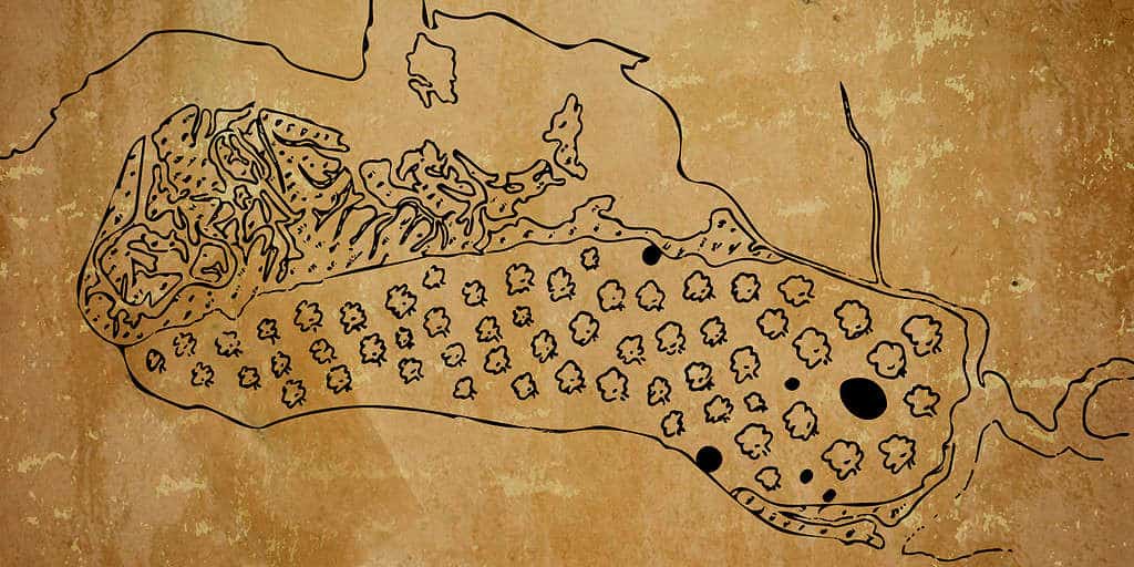
Notable shellmounds, like the Emeryville Shellmounds, Alameda Shellmounds (near Mound Street), and the Drake’s Bay Shellmounds were being studied during their destruction.
Schenck wrote the “final” report on the Emeryville Shellmound. These are two pictures from that paper.
The Bay Area had over 425 shellmounds. Though many of them were already gone by the time Nelson conducted his survey of the SF Bay Area.
This map is offered to the public in an effort to:
Educate the public about the prevalence of shellmounds in the San Francisco Bay Area;
Present “Native Land”, and “Indigenous Land” as something tangible, and literally all around us;
Help illustrate colonization’s impact on Indigenous Landscapes, and Native American Cultural Resources, such as Sacred Sites, and Shellmounds–which are actually cemeteries;
Most of all, this map is made available to provide actionable information which the public can use to help “Save the Shellmounds”, and advocate for Sacred Lands which have been shrouded in secrecy since the passage of NAGPRA.
The Native American Graves Protection Repatriation Act was supposed to help protect land, by providing a Notification and Consultation process to Tribal Nations.
But the law effectively prevents the public from being told about the true scope, nature, and importance of Tribal Cultural Resources.
NAGPRA also allows development to continue under any circumstances, as long as a mitigation plan is presented and approved, according to the CEQA process.
However, when one actually reads the CEQA filings related to projects on Sacred Lands, you can’t help but notice the majority of these projects are approved without any input from Tribal Nations, at all.
Because there is no legal avenue for protecting land if you are not the Most Likely Descendant, as determined by the California Native American Heritage Commission….
And, because the public is barred from learning about the Nature, Scope, Location, Use, or any other information regarding Tribal Cultural Sites, Items, Graves, etc. it is virtually impossible for the public to advocate for the conservation, and preservation of Sacred Lands. Much less learn why these sacred sites are important, and should be preserved.
The blackout on this information also affects the ability of cities to participate in goodwill building, like re-zoning areas for open space to be returned to Tribes; or educating their citizens about the first inhabitants of this area, and the importance of preserving these heritage sites.
The Map of the Shellmounds of the San Francisco Bay Region is just one tool in the Land Back Toolbox.