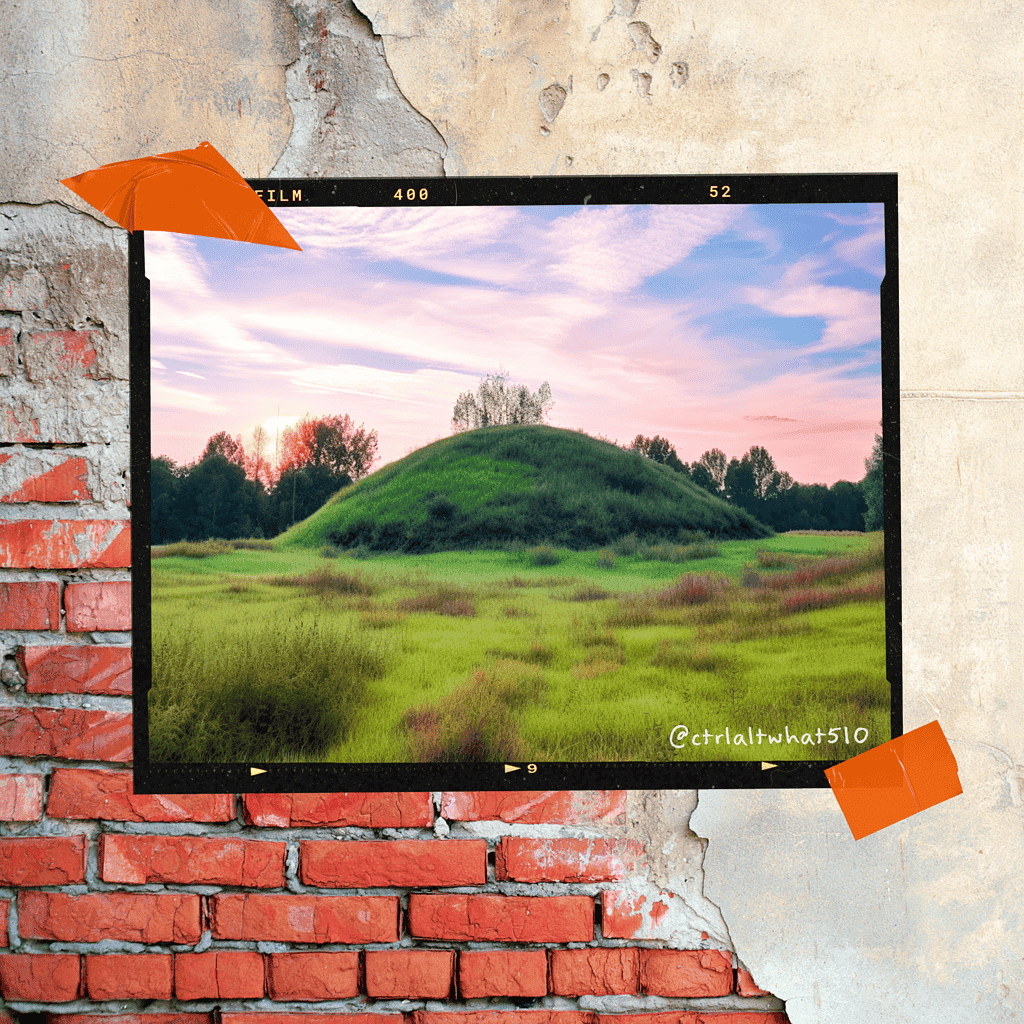
A shellmound is a graveyard, a mortuary complex, an ancient structure. It’s a place where the first peoples who live along the coasts and rivers of California, used to bury their dead. This article briefly explores why that is.
Spanish Influence on Indigenous Use of Shellmounds
This missionization of local indigenous people can be characterized by the abduction, forced baptism, and slavery of Indigenous people by Spanish Priests and Conquistadors. And, the outright theft of natural resources (like food) which indigenous people had helped cultivate and depended upon for all of their food, medicine, building materials, etc.
In spite of the homefield advantage, and larger numbers, indigenous people could not defeat the colonizing Spanish force.
When Spanish colonizers had ruined the ecosystem by grazing, logging, razing, and waste, indigenous people found themselves with little choice but to join the missions or flee to places outside of the reach of the mission system. (In reality, no Indigenous Californians were safe from the missions, except those in the far North of California, where Missions did not exist.)
Because the Missions were located in Central Areas; and because of the Area of Influence Spanish Invaders were able to exert dominance over was so vast (due to horses); indigenous people of the area known as the Bay Area were forced to abandon their burial practices because they had to abandon the land their graveyard was situated upon.
This meant that indigenous people had to figure out how to bury their dead using the resources found away from the coasts and rivers they were used to.
It also meant that, indigenous people were being buried in graveyards at Catholic Missions all around the Bay Area.
American Influence on Indigenous Use of Shellmounds
Soon, American aggressors would begin to appear in what they though was their frontier land; an “Indian Frontier”. This was during the time of the “Wild West”, when Indian Wars were being actively fought.
The Indian Wars would be romanticized for years to come in newspaper stories, and on the screen especially during the 1950’s with such films/shows as:
Winchester ’73
Gunsmoke
The Lone Ranger
Davey Crockett
They Died with Their Boots On
But there was nothing romantic about the real story of the California Genocide.
Americans would purposely destroy or vandalize sacred sites for entertainment or out of spite. One famous shellmound, in Alameda, California, was used to pave Bay Farm Road in 1908. The bodies of ancestors were routinely ground up and used as aggregate for cement, or even calcium enrichment for roses and other flowers (instead of eggshells.)
Militias were paid by the United States Government, and (later) the State of California, to hunt and kill all indigenous people. The United States Army “expeditions”, especially what they liked to call “punitive expeditions”, were marked by the execution of indigenous men, and the rape, torture, and mass-murder of indigenous women and children.
In 1848, the area now known as California was ceded by Mexico, at the end of the Mexican-American war. Two years later, California would officially earn statehood, and its first governor, Peter Hardeman Burnett, during his first State of the State address mentioned the California genocide explicitly.
“A war of extermination will continue … until the Indian race becomes extinct,” Peter Hardeman Burnett, the First Governor of California continued, “the inevitable destiny of the race is beyond the power or wisdom of man to avert.”
Now, all Indigenous people were actively under threat by all white people, who were paid for each “Indian” they killed, baby they stole, or person forced into slavery via “prisoner debt” to white business and property owners. Prison debt was money owed to a person or business for a crime committed against it. These were often times for extraordinary amounts of money which the debtor was only able to pay through involuntary labor or servitude. The prison debt system was created to control Indigenous People, and People of Color, and prevent them from gaining any foothold or capital in a society and world which white people viewed themselves as being solely entitled to because of their religious or racial beliefs.
Once Native Californians were being displaced, forced onto reservations, into indebted servitude, boarding schools, orphanages; and their burial places forced abandoned, and desecrated by American invaders. Many indigenous people began the practice of cremation. One of the most common reason for why someone is cremated was because they wouldn’t be able to be buried with their ancestors, next to their loved ones, or with their family or tribe. It was better to live the afterlife free of their body than to have it defiled.
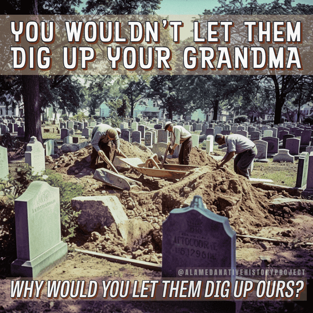
Save Shellmounds Not Parking Lots campaign image of archaeologists sifting through soil in a cemetery. Title reads: “You wouldn’t let them dig up your grandma. Why would you let them dig up ours?”
The San Francisco Bay Area had well over 425 shellmounds.
Gabriel Duncan, from the Alameda Native History Project, estimates the true number of shellmounds around the S.F. Bay Area’s shoreline is closer to seven or eight-hundred shellmounds, which existed before European invasion and colonization.
Shellmounds are ancient burial grounds used by the First People of the San Francisco Bay Area for over 10,000 years. Shellmounds form ancient mortuary complexes created by Ohlone, Miwok, and Karkin people. Shellmounds were not village sites; but they were places where ceremonies dedicated to indigenous ancestors were performed; and large seasonal gatherings were held nearby to celebrate the unity, harmony, and balance indigenous people share with the earth, each other, our ancestors, and all creation.
Grave robbing by universities and treasure hunters; as well as desecration by railroad companies, oil refineries, and quarry operators, has made the remaining San Francisco Bay Area Shellmounds one of the most endangered cultural resources in the world.
One of the chief defilers of shellmounds are quarry companies. These companies are still operating today, at places like the San Rafael Rock Quarry–which is home to no less than five shellmounds; and Dutra Materials Quarry, in Richmond, California–an area dotted with the highest concentration of shellmounds in the East Bay.
But not much is being said about the historical and ongoing desecration and defiling of indigenous bodies to build the infrastructure and institutions all around us.
This is surprising, considering the amount of time, effort, and fundraising which has gone into “preserving” a parking lot in West Berkeley, and protesting a thriving and established shopping mall in Emeryville, California.
While other cities and corporations used shellmounds to level their train tracks, and pack for roadways: the Angel Island Immigration Station is one of the best surviving answers to the question of “What Happened to the Shellmounds?”
Angel Island was home to about four shellmounds. All of which were quarried and used as a base for the concrete to construct the immigration buildings now standing as Angel Island State Park. However, there is no mention of this fact in the park brochure, or uttered by any tour guide on the island.
The historical and continuing desecration goes unspoken, and right before our very eyes; all over the San Francisco Bay Area.
Instead of directly addressing and challenging the corporations and cities responsible for the desecration of Ohlone, Miwok, and Karkin burial grounds, and sacred sites: advocates and allies are being fooled into believing these parking lots (in West Berkeley), and post-industrial waste sites (in East Oakland) are the priority for the fight against desecration of indigenous land. This is not true.
“Saving” parking lots is not an indigenous priority over stopping the desecration of indigenous sacred sites today.
Optic-driven, PR events, like urban gardens, and cultural easements to use our own land for free, do not address the fact that shellmounds are being quarried into extinction. That these ancient structures are being erased by shoreline development, and urbanization of the San Francisco Bay Area waterfront.
This situation will not change; the desecration will not stop, until our supporters and allies start to critically assess the information being given to them by non-profit corporations trying to fundraise for their money, and compare that with information provided by scholars, experts, and bona fide tribes like the Muwekma Ohlone Tribe of the San Francisco Bay Area.
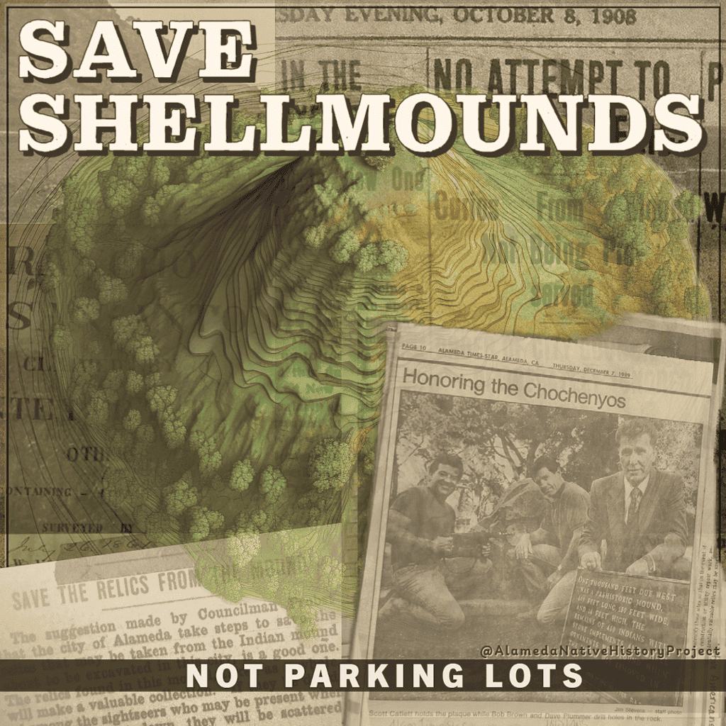
Collage art of a shellmound with historic Alameda newspaper articles in the background, with the title words “Save Shellmounds Not Parking Lots”. Artwork by Gabriel Duncan.
While these places may be on our traditional homelands, and within our tribal territories: Brownfields properties and Supferfund sites are neither appropriate, nor respectful gifts of atonement to the Indigenous People the entire Western Hemisphere was stolen from.
It is a waste of resources for indigenous non-profiteers, like Corrina Gould, to focus primarily on post-industrial sites, like the place she alleges is the “West Berkeley Shellmound“.
It is an improper use of our allies’ time, energy–and money–to have them marching around an empty parking lot, and futilely protesting an established and thriving shopping mall (Bay Street Emeryville).
All of this takes away from the reality: Ohlone cultural resources in the San Francisco Bay Area are being destroyed by development at an alarming rate.
Without intervention, Native American cultural resources, like shellmounds, and the fragile ecosystems they inhabit and have supported for over 10,000 years, will be destroyed. Paved over, without a second thought for anything other than their “fair market value”.
Parking Lots and Abandoned Post-Industrial Spaces are not a priority; compared to Federal Recognition, Federal Land Grants, and the establishment of a Tribal Land-base and an official, recognized, Ohlone tribal reservation, and sovereign tribal territory.
Urban Gardens do not address the Land Back movement in a relevant way.
In fact, PR events like the dedication of part of Joaquin Miller Park, in Oakland, and the renaming of a park in Alameda, are completely irrelevant to the actual cause of land back, rematriating the land, and the real priorities of bona fide tribal governments, like the Muwekma Ohlone Tribe of the San Francisco Bay Area–a tribe Corrina Gould would be a member of, if she weren’t so focused on personal gain, instead of advocating for her own tribe, and all Ohlone people.
As long as people realize their time and energy is better spent on an achievable goal, like Federal Re-Recognition & The Establishment of a Muwekma Land-base: Land Back is something we can see happen within our lifetimes.
For more information on how you can help Ohlone people regain Federal Recognition, and get their Land Back, visit the Muwekma Ohlone Tribe of the San Francisco Bay Area’s website at: http://muwekma.org
It’s hard to say exactly what this plaque meant to me, growing up, adopted, in Alameda. This was a tangible symbol of my Native American heritage; something connected to my identity. Proof that my people actually existed somewhere. Even though I couldn’t see them, or be with them. It was also a source of horrors; knowing that I was living on an Indian Burial Mound.
This was supposed to be an art project; with some ghost stories, hand made beading, and hand-made historic reproductions of traditional Native American garments and adornments.
All I wanted to do was find out if my grandfather’s house really was built on an Indian Burial Mound. I thought I was asking a simple question, that local historians would be able to answer in the same way they could erudiate on Victorian Houses, and Electric Railways.
Instead–when I went to the Alameda Museum–the subject was dismissed.
“Somebody already did that,” I was told.
An unnamed docent from the Alameda Museum asked me, “Wasn’t it just a trash heap?”
Searching For Answers
It soon became obvious that Non-Native Historians were neither interested, nor knowledgeable about the Alameda Shellmounds, or the First Alamedans; I realized I would have to perform the work.
Not just to find out for myself; but to counter non-native apathy, and gate-keeping; and hold this knowledge in trust for other native people who search for their own heritage, too.
But how do I find out more about the Alameda Shellmounds, and their history, when the Alameda Museum doesn’t even care?
I would have to find, search, index, and analyze several volumes of information; across several sources, and locales.
This is the progression of sources I consulted, regarding this topic. Research is still ongoing. Check the ANHP Wiki for specifics, excerpts, transcriptions, and more.
Existing, Aggregated Information RE: Shellmounds in Alameda
Books:
Alameda: A Geological History, Imelda Merlin, 1977
Shellmounds of the San Francisco Bay Area, N.C. Nelson, 1914
Alameda Historic Records
Learned:
Where the “Sathers Mound” actually was;
There was more than one shellmound in Alameda;
People used shellmounds to pave sidewalks and roads.
Newspapers
Search expanded to regional and state newspapers; like the Oakland Tribune, and the Alta Daily California.
Learned:
First excavation of the Alameda Shellmound was 1892, sponsored by the San Francisco Call newspaper;
California Academy of Science was involved in 1892 excavation;
Several artifacts reportedly gifted to U.C. Berkeley Anthropology Museum.
University/Research Institutions
Relevant material found in the holdings of:
University of California, Berkeley;
San Francisco State University;
California Academy of Science.
Museums
Phoebe A Hearst Museum, Berkeley, California
California Academy of Science, San Francisco, California
Coyote Hills Regional Park, Fremont, California
California Indian Museum and Cultural Center, Santa Rosa, California
California State Indian Museum, Sacramento, California
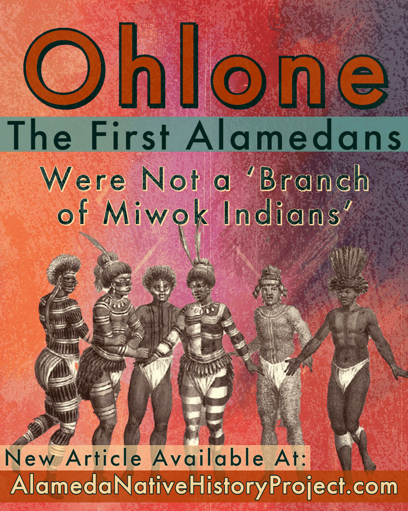
Alameda Museum, Alameda, California (Errantly attributed Ohlone artifacts to “a branch of the Miwok tribe” for decades.)
“Somebody already did that.”
Imelda Merlin
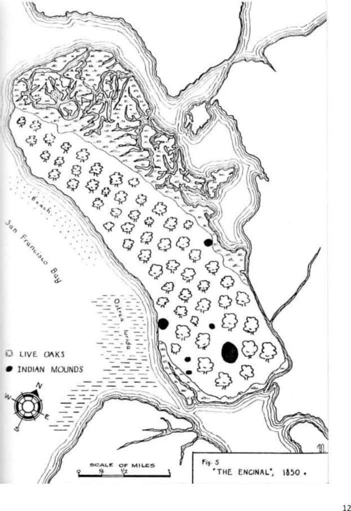
Imelda Merlin is a famous Alamedan. Her Master’s Thesis for the University of California, Berkeley, was published in 1977 as Alameda: A Geological History. This book contains a Map of Live Oaks, which features several shellmounds.
Imelda Merlin’s book is considered the “Alameda bible” as far as local historians are concerned. It contains excerpts from, and references to, some of the core historic records of the City of Alameda. However, the map is of Live Oaks, and does not appear to be a serious attempt to show the accurate locations of shellmounds which existed in Alameda around 1850; and the sections concerning indigenous occupation of Alameda and extremely light on verifiable citations.
N.C. [Nels Christian] Nelson
Was an anthropology student at the University of California, Berkeley. Worked for John C. Merriam. Merriam and Nelson both went on an exploratory expedition of the San Francisco Bay Region, where Nelson surveyed and analyzed shellmounds.
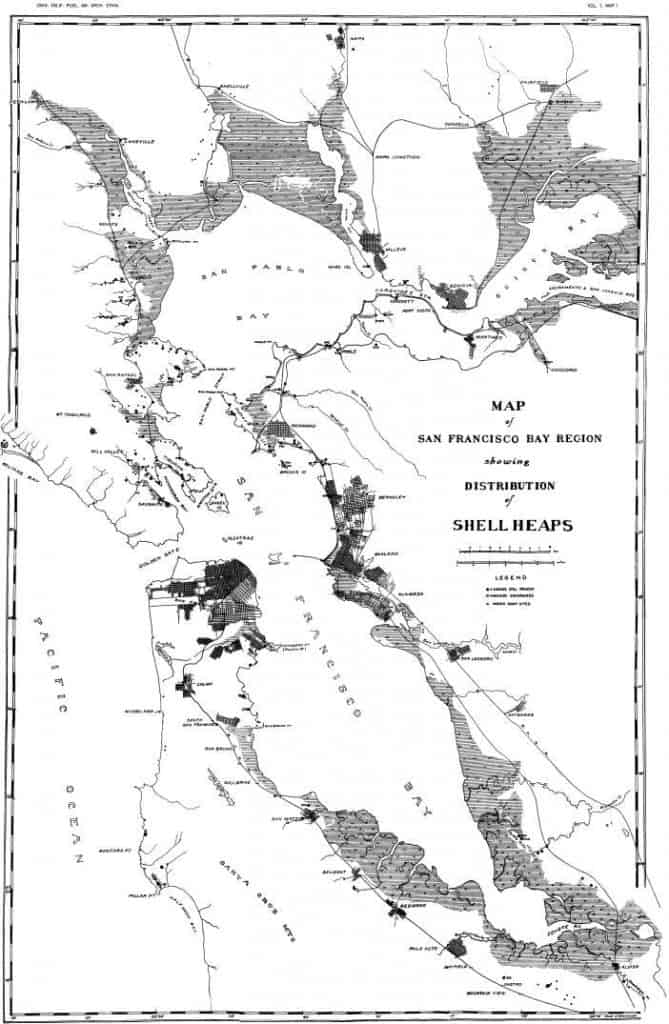
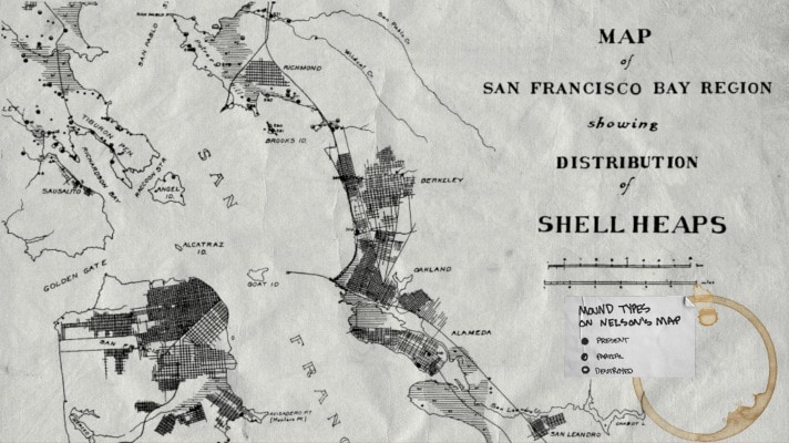
In 1914, N.C. Nelson published his findings in “Shellmounds of the San Francisco Bay Region”, which featured the “Map of the San Francisco Bay Region, Showing the Distribution of Shell Heaps”.
This is the most thorough survey of the Bay Area Shellmounds ever made; and Nelson’s work is heavily cited by historians, newspapers, and researchers, alike. Nelson’s map represents the positions of shellmounds he and his team personally observed, which makes his work a primary source.
Confronting the Current Record
Reconciling local “common knowledge” with Public Records and Official Studies
Issues presented by Imelda Merlin’s Map
Citations are missing, incorrect, and/or do not substantively match or explain the locations of shellmounds in content, or context. For instance, the 1850 “Whitcher’s Survey” map of the Alameda area has been lost to time, even though it was referenced as being on prominent display in Alameda’s City Hall. This survey appears several times in Merlin’s work, all with hand-drawn additions by Imelda Merlin, herself.
Multiple Versions of N.C. Nelson’s Map
Aside from the official U.C. Berkeley, University Press printing of Nelson’s Map; there are versions with more Shellmounds, and different numbers. However no addendum or update by Nelson has been recovered; drawing into question the accuracy of these other, unofficial, maps purportedly attributed to Nelson.
Complete Reliance by Non-Native Historians on Unvetted Sources
Hometown pride may have blinded local historians. But even credible witnesses can give unreliable testimony. There is an argument for considering Merlin’s map as a Tertiary Source.
Non-Native Attitudes that the Burial Mound Issue is “Settled”
Resulting in a fundamental lack of knowledge and comprehension of local historical events by local historians and curators–who are supposed to be the experts on this subject, among other Alameda History. The assumption that there is nothing more to find, and no more to learn about the Alameda shellmounds, meant that no research was performed regarding the History of the First Alamedans–until now.
As this project continued, I learned that there was a lot left unsaid, and even more Alameda History to be uncovered beyond answering the question: “What happened to the shellmounds?”
This is an excerpt of a letter sent to ARPD’s Amy Wooldridge, the Alameda Recreation and Parks Department Director; as well as City of Alameda Mayor Marilyn Ashcraft, Vice Mayor Malia Vella; and Council Members: Tony Daysog, Trish Herrera Spencer, and John Knox White [who made the original announcement concerning the indigenous land management of property on Main Street, between Stargell and Singleton.]
Hey Amy,
Thanks for getting back to me so quickly. I wanted to address two things.
1. The Confederated Villages of the Lisjan Nation, INC. is not a Tribal Government; it is a nonprofit corporation.
The name of the true Ohlone Tribe of this area is the Muwekma Ohlone Tribe of the San Francisco Bay Area.
Muwekma has been known as “Costanoan”, the “Verona Band”; and they have self-identified as “Yo soy lisjannes” [“Chochenyo Field Notes”, Harrington, 1921]. Additionally, the present-day Muwekma Ohlone Tribe is comprised of all of the known surviving American Indian lineages aboriginal to the San Francisco Bay region who trace their ancestry through the Missions Dolores, Santa Clara, and San Jose; and who were also members of the historic Federally Recognized Verona Band of Alameda County. [Muwekma.org; as well as both their BIA petitions for federal recognition.]
Federal Recognition could help Muwekma in the following ways, as they relate to ARPD, and the City of Alameda’s relationship with CVL:
A Land Base would be established for Muwekma in the Bay Area,
This may include ANAS/FISC Alameda property; and other open space in the City of Alameda.
Land Banks held by agencies like the East Bay Regional Park District will be transferred to Muwekma
Muwekma would be endowed with the Legal Standing required to bring suit for the cessation of excavation, destruction and/or development of Tribal Cultural Resources in the City of Alameda–
And, this might leave ARPD and the City liable, should they irrevocably devote land and resources to a corporation that is not actually a tribal government (please be careful, because we need our Parks and Rec Department; it would suck if they lost funding because it was reappropriated as restitution, or a settlement.)
Theoretically, there should also be a conveyance from Sogorea Te Land Trust to the Muwekma Ohlone Tribe of the San Francisco Bay Area at this point–as Federal Recognition would render the necessity/mission of a land trust to hold land for an unrecognized tribe moot.
Aside from the factual issues with recognizing a corporation less than 5 years old as a Tribal Government; there is the political consideration.
Muwekma is a tribal nation that is trying to regain federal recognition. One of the most crucial elements they must prove in their petition is that Muwekma has existed as a continuous group since the last time they were recognized as a tribe; and that the tribal governance structure has retained its political influence on said group. This has been extremely difficult for them to plead at the level the BIA requires. And several prominent politicians have spoken out against what they believe is an arbitrary and capricious refusal by BIA to reconsider Muwekma’s petition for tribal recognition. [This is on top of previous judicial opinions also in favor of reconsideration.] But, there is another way that Muwekma can regain Tribal Recognition; and that is by an Act of Congress.
However, to affect this action, Muwekma must have a broader political influence beyond its own membership. This means they would have to gain wider public support for their cause, in order to effectively encourage congressional representatives to introduce legislation renewing Muwekma’sTribal Recognition.
I believe that the City of Alameda, and ARPD’s public endorsement of the Confederated Villages of the Lisjan Nation, INC. as an Ohlone tribe is an error which is detrimental to the rights and struggles for recognition and sovereignty of the Muwekma Ohlone Tribe of the San Francisco Bay Area insomuch that it lends false validity to a corporation that is fraudulently portraying itself as a Tribal Nation to benefit a small group of people over the needs of thousands of bonafide Muwekma Ohlone Tribal Members.
It also contributes to the erasure of all of the people whose ancestors were ground up to pave Bay Farm Road; grade former train tracks in Jean Sweeney; and fill marshland around Krusi, and Harrington Parks, among others.
It is for these reasons that I strongly suggest ARPD, and The City, reach out directly to the Muwekma Ohlone Tribe of the San Francisco Bay Area before you consider doing anything else.
2. Ongoing Contamination of Soil and Groundwater At or Near Linear Park (On Main Street, between Singleton and Stargell)
I’m concerned about the most recent Groundwater Ambient Monitoring and Assessment data regarding Benzene and Naphthalene found in ground water samples around this site. These chemicals were found in 2021 data, and no mitigation activities have occurred, as this site is now open and being investigated. It’s reasonable to assume that groundwater contamination is transient, and could affect Linear Park because it has a drainage ditch well below the surface of the surrounding land, including all sites appearing on the map below. This is the same drainage ditch Tule grows in now.
Additionally, I would like to note that Linear Park itself has been subject to contamination from leaking underground storage tanks (UST’s); which contained gasoline, diesel, lubricating oil, waste oil, and other hazardous materials; which released harmful chemicals, including the two listed above (among others), into the soil and groundwater directly upon the property now referred to as Linear Park.
There are also 26 points within 1,000 feet of Linear Park which have been affected by soil and groundwater contamination, much of the land surrounding Linear Park are subject to Land Use Restrictions expressly against digging/excavating, or using groundwater. Some of these Land Use Restrictions prohibit Schools or Housing from being built on those parcels because of the risk to human health (specifically to children.)
Additionally, there is the existence of the Toxic Marsh Crust, which lies 4-18 feet below the surface of any given point on the map presented here, and presents an unknown and unmitigated hazard to any plant or animal for the foreseeable future. For your reference, the highest water level sampled for this area was given at 3 feet below ground surface (BGS); and the drainage ditches are at least four feet deep.
Please find the attached PDF “CLOS_L_2002-01-14.pdf” which is a letter from the Alameda County Healthcare Services Agency, Environmental Services, Environmental Protection, Hazardous Material Specialist Eva Chu, addressed to the City of Alameda. This document details the contamination at the point where the tule grows in Linear Park, at Singleton and Main Street. This letter notes current concentrations of hazardous materials, and examines how the underground storage tanks were removed, and the land treated.
On top of the soil used for backfill being contaminated, polluted groundwater pumped from the site was sprayed onto the soil to suppress dust during work… further contaminating an area that was supposed to be cleaned.
All of this points to:
A strong possibility that the soil and groundwater harbor contaminants dangerous to humans;
The certain necessity to test soil and groundwater in this area to determine its safety.
Furthermore, certain safety plans must be created before digging, trenching, or groundwater may be used. The attached report also states that the corrective action for this parcel must be reviewed if land use changes.
Currently this land is technically wetland and flood mitigation for tidal surges which typically flood this area. The proposed use: to grow plants for food, clothing, and medicine to be consumed, inhaled, smudged with (,etc.); is clearly a much different use[–for human consumption vs. flood mitigation]. Therefore the re-evaluation of these parcels is not just a good idea, it is an enumerated necessity, according to Hazardous Materials Specialist Eva Chu.
Please find the attached “Map Showing Past & Present Contamination in City of Alameda Proposed ‘Indigenous Land Management’ Parcels”
It is for these reasons that I strongly object to letting anyone manage any part of, or consume any thing from Linear Park–at all–until the question of contamination has been thoroughly examined, and competently settled.
Thanks for your attention to these matters. If you have any questions, feel free to reach out to me.
Alameda Native History Project releases a new Alameda Shellmound Map Model to show the capability of Augmented Reality, when it comes to virtual classrooms, and independent & remote learning. And to showcase the direction of education, and uses for technology, as we progress further into the 21st Century.
This map is appropriate for use in a K-12 setting; and represents the Alameda Shellmounds, as seen by N.C. Nelson. [“Shellmounds of the San Francisco Bay Region”, Nelson, 1909] This map model was created by Gabriel Duncan, and it was stylized using Adobe Aero.
Alameda Native History Project is not sponsored by, or receiving money from Adobe. This is not a paid product placement. This is an example of how to use the tools already available to you, for free, to make really cool stuff for your class or presentations.
For more information about this model, or how to get a copy, email the Alameda Native History Project.
The Alameda Native History Project project presents a map of the three Alameda Shellmounds, as seen by N.C. Nelson in 1907, restored and presented in the present-day landscape.
For the first time ever, the Shellmounds of Alameda are being visualized, and presented as a physical, tangible land feature.
The purpose of this map is to:
Acknowledge that Alameda was a place were local Ohlone communities came to bury their loved ones;
Illustrate the large size and scale of shellmounds, in general;
Visualize a theoretical landscape where the Alameda Shellmounds were preserved;
Fill the gaps made by Alameda Museum’s lack of accurate or meaningful information about the First Alamedans: Ohlone People.
Created using derivatives of open-source data, including (but not limited to) USGS, NOAA, USCG, NASA, Google Earth. Analyzed, processed, and produced by the Alameda Native History Project, using open-source software available to anyone with a smart phone, and the most basic computer.
Why did the Alameda Native History Project create these maps?
Necessity
The first map created by the Alameda Native History Project was the geographicaly-conformed (or “geo-conformed”) version of N.C. Nelson’s historic 1909 Map of the San Francisco Bay Region Showing Distribution of Shell Heaps. This 20th Century version of Nelson’s map was painstakingly converted, and conformed, to 21st century Geographic Coordinate Systems.
Geo-conforming Nelson’s map made it possible to accurately plot the coordinates marked on Nelson’s map; and perform Present Day Observations of the Bay Area Shellmounds.
The San Francisco Bay Area Shellmound Map now has over 300 confirmed locations. The accuracy of this map has improved considerably over time; and the research version is now accurate to within 100 feet.
This was because maps like those featured by the Stanford University’s Spatial History Lab were little more than photocopies of the original coastal surveys, with graphic overlays.
While this might be impressive to some, the lack of any real functionality or new information derived from this kind of exercise was underscored when I tried to find/use this information in the context of the Shellmounds of Alameda.
Stanford University, Spatial History Project1909 N.C. Nelson Map of the San Francisco Bay Region Showing Distribution of Shellheaps
This made it necessary to recreate a map of the historic shoreline of the San Francisco Bay Region, and hand-plot more than 300 shellmounds, just so I could view these maps and take screenshots of them to share with you. All in an effort to show you where the Shellmounds of Alameda are.
Clarity
Reproduction of Whitcher’s Survey.
The same geo-conformance process was applied to an historic map of Alameda, which has become the Alameda Museum’s sole reference concerning the shellmounds of Alameda: Imelda Merlin’s “Alameda: A Geographical History”. This book is a Geology Master’s Thesis, by Imelda Merlin, who lived and died in Alameda, California.
The fact that Merlin was an Alameda resident; and that Alameda Museum owns the copyright to the book should be immaterial to the generally dubious nature of a photo-copied map, with hand-drawn notations.
In spite of the fact that Imelda Merlin was a student at the University of California, Berkeley, it appears that the most relevant information created by N.C. Nelson–for the archaeology department of the same university–was avoided altogether by Imelda Merlin in her work.
For the aforementioned reasons, it was determined that Imelda Merlin’s work merited careful scrutiny and interrogation.
Because, at this point, I already had two other sources of location information compiled for the Alameda Native History Project:
1. Public Records Aggregate
Any mention of Alameda Shellmounds in the following archives/libraries/collections:
All references to the Alameda Shellmounds at the Alameda Free Library:
this includes references in the Historic Alameda Newspaper Archives, and the “Alameda Historic Reels”;
as well as Clipping Files, Alameda Historical Society Card Catalog [Defunct];
Library Catalog, and Special Collections.
Online Newspaper Archives, Indexes
Online Finding Aids
Genealogy Websites, National Archive, and More.
References were logged, and copies of the documents were saved. Then the documents were analyzed, information was extracted, and processed to produce an aggregated list of locations of the Alameda Shellmounds–according to explicit references in these sources.
Then the locations were geocoded, and plotted to create a map that … I don’t even know what to call. “Shellmounds Mentioned in the News”?“Historic Shellmounds”?
“Public Records” is not a very attractive label; but it might be the best label for that layer on the Alameda Shellmounds Map. [So, in case you ask “What is the Public Records Layer on the Alameda Shellmounds Map”, now you know.]
2. Nelson’s Map of the SF Bay Region Shellmounds
Like I said, this was the first map I painstakingly recreated. So, therefore, I had the locations Nelson marked within Alameda.
When I analyzed the base map printed in Imelda Merlin’s book, I was able to use these sources to help conform Merlin’s base map with current Geographical Coordinate Systems, so I could plot the positions marked in the Imelda Merlin layer in the Alameda Shellmounds Map.
I used innumerable copies of maps, surveys, photographs, and other visual representations of Alameda, from 1880 to 1910 to help conform the “Whitcher Survey” referenced in Merlin’s Map. I was never able to find a true copy of the “Whitcher Survey”. The survey is not at City Hall–as Merlin’s book states–or in the Alameda Free Library. The Museum did not have it, at last check.
I also looked to see if any map copy provided by the official website of a University, or Government Institution, or the publisher itself, or a credible archive, actually included similar shellmound positions during the time Merlin’s map was created.
TL;DR: they do not. Not even the Land Grant Case Maps, or the legit Combined, Drafted, or Official Coastal Surveys of that time, have even a hint of a shellmound anywhere. (I even tried to find a copy of the coastal survey used in a well-known documentary about the Shellmounds of West Berkeley, but was unable to track down the file before publication.)
However, even though Merlin’s map diverges from the Official Historical Record, she did capture something in her hand-drawn sketch: all of the dots on her map correspond to places where Ohlone graves have been found.
In spite of the fact Merlin calls the First Alamedans “Miwok”–instead of Ohlone. In spite of the fact that Merlin doesn’t even mention the map in the actual narrative (or “text”) of her book. In spite of the fact that the map was published in her thesis (which was then published a few years later, in a book) without any references, or citations–aside from the coast survey base map.
Somehow, she manages to highlight the same places I have located using mentions of Ohlone graves and Native American remains found in historic Alameda newspapers. Many of these discoveries happened decades after the publication of Merlin’s work. …Which could indicate that these discoveries are coincidences, rather than correlations.
It makes sense that the discovery of human remains would be carefully guarded; only mentioned in whispers between Alameda insiders, and related professionals. Certainly, the newspaper would be encourage to leave anything like that out. … At least until the houses were sold.
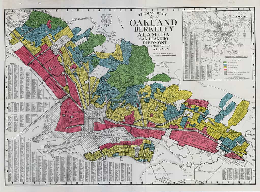
It’s not hard to have editorial control when real estate companies were the primary revenue sources for local Alameda newspapers. Furthermore, the Redline wars in Alameda were brewing long before residents voted to approve Measure A, in 1973.
In a “closed”, racist, housing economy, where BIPOC are excluded, and declining property values could be caused by even a whisper of non-white interest in a neighborhood: the prevalence of bones underfoot could undermine the appeal of an entire city.
Historic Redline Map showing Oakland, Berkeley, and Alameda
Alameda was probably a place where the surrounding Indigenous communities would come to bury their dead.
When you take into account historic newspaper articles like the one below (from 1893;) and the preponderance of subsequent articles concerning Native American Graves and Remains found, and then plot those locations into their own map, you get a layer of “Remains & Relics Found”.
While it is the Euro-Centric imperative to determine a single point; and explicit boundaries: the size and nature of the shellmounds was as much a mystery to these colonizers as it is to us today. For different reasons though.
Early anthropologists, archaeologists, and ethnologists lacked the imagination necessary to make the logical leaps necessary to recognize the purposefully obscure nature of our infrastructure, or decode the metaphors we left in notes and drawings for our friends.
Because of this, and because white people destroyed as much of our stuff that they possibly could (on purpose [I don’t know why]), we are now–in many cases–left with the remnants of remnants.
Because the records concerning these events, and the mere existence of the massive burial grounds under the City of Alameda, and the cities of the rest of the San Francisco Bay Region have been actively concealed, and suppressed, this story has remained untold.
“Alameda’s Indian Mounds“, published in The San Francisco Examiner, on Sunday, March 26, 1893:
“When the progressive Alamedan decides to build a home of his own on a section of the encinal that have been allotted to him by his favorite real estate dealer…
“He does not order work suspended when the excavators, who have undertaken the task of building his prospective basement, run across a well preserved skeleton or turn up a hideous looking skull.
“He has become used to such things and he knows…
“in all Alameda there is scarcely a square yard of ground that does not harbor the crumbling remains…”
The pieces of the puzzle can still be found.
And so, Nelson’s Map, Merlin’s Map, and the Public Records map were offered as three separate layers of the Alameda Shellmounds Map; so that you may also discover and analyze the similarities and differences between the locations, yourself.
The other layers mentioned, such as “Remains & Relics Found”, and more are also available to view using the layers panel of the Alameda Shellmounds Map.
As our records continue to grow, and new information found, the map and this site continue to grow as well.
Aesthetic & Availability
Let’s face it: no one wants to look at nth generation copies of copies.
I don’t know about you, but I’m tired of trying to squint, and adjust brightness, contrast, and gamma until I can barely almost read the most important part of this chapter….
I want to look at a webmap of the San Francisco Bay Area Shellmounds. I need my experiences to be more interactive, and offer more than an empty citation to a book I can’t even find anymore. I want to see a scan of the book. And read the citation myself.
But even that’s not enough. I find myself getting triggered by the language of these old, dead, white men that I just want to fight.
Most of these narratives are written from an all-white perspective, often using racial slurs, and offensive descriptions. For the past 74 years, the Alameda Museum has furthered the “gentle savage” myth that permeated Victorian Era culture in America. And continues to push the idea that Ohlone people just disappeared from Alameda, and the Bay Area, entirely.
It’s been the same narrative since “time immemorial”. (Even that phrase is from a white-washed narrative meant to pander to a White Gaze that isn’t even a majority anymore.)
California History, when it comes to Indigenous People, is broad, at best. Very little space or effort is given to properly naming, or describing Native Americans, how they looked, where they lived, what they ate….
Most textbooks will even allude to American Indian relationships with White People as something symbiotic; and leave this chapter of history conveniently blank, to make room for the concept of Manifest Destiny.
The history that we are being taught has specifically avoided the policy of indigenous extermination enacted by a California Governor in the late 1800’s; California’s military support of Indian Wars in Oregon in the early 1900’s; or, how Los Angeles stole water rights from Tribal Nations in the Central Valley and has helped to destabilize the California ecosystem, with devastating effects.
We are not taught about this.
We have instead been dazzled by trains, bridges, and pretty houses with gardens, like babies with a ring of keys.
California is the most diverse state in terms of Tribal Nations, with over 300 Indigenous Languages Spoken in California, alone. We are astronomers, conservationists, artists, engineers, doctors, and so much more. Our stories and contributions matter.
Ohlone people still live in the San Francisco Bay Area. The Muwekma Ohlone Tribe of the San Francisco Bay Area could use your help in fighting for federal recognition.
The Native American, Indigenous People that you speak of like they went extinct in the 1800’s; those people are my great-grandparents.
The first step in justice for Indigenous Californians is recognizing us.
This is why it’s important to update the aesthetic of Historical Curation, and Exhibition Design, to utilize the tools we have in the 21st Century to reach learners everywhere, using the interactive multimedia methods they use and engage everyday.
Alameda Native History Project’s map of the Shellmounds of the San Francisco Bay Area is available now.
This map is based on N.C. Nelson’s “Map of the San Francisco Bay Region Showing Distribution of Shellheaps”, which was published in 1909. This map, represents the first-hand observations of shellmounds during N.C. Nelson’s survey of the San Francisco Bay Area. taken between 1907-1908.
Excerpt of map, emphasis on map legend, showing “Present”, “Partial”, and “Destroyed” shellmounds. These symbols are more prevalent in the North Bay.
Each marker on the SF Bay Area Shellmound Map represents a shellmound which Nelson marked as “present”. These mounds appear as solid dots in his map. Nelson also noted mounds which were partially present, as well as shellmounds he was told used to exist in the past.
It’s important to note that–in Nelson’s paper, “Shellmounds of the San Francisco Bay Region”, and similarly in many other publications of the time–archaeologists were engaged in what they considered “Salvage Archaeology“.
During the time that these scientists were ignoring the California Genocide, and Indian Wars, archaeologist, anthropologists, linguists, and ethnologists all decided that Native Americans were extinct; and that graves and other Native American Cultural Resources should effectively be raided, before they were destroyed by the encroaching colonizers, or gluttony of their civilization.
Notable shellmounds, like the Emeryville Shellmounds, Alameda Shellmounds (near Mound Street), and the Drake’s Bay Shellmounds were being studied during their destruction.
Schenck wrote the “final” report on the Emeryville Shellmound. These are two pictures from that paper.
The Bay Area had over 425 shellmounds. Though many of them were already gone by the time Nelson conducted his survey of the SF Bay Area.
This map is offered to the public in an effort to:
Educate the public about the prevalence of shellmounds in the San Francisco Bay Area;
Present “Native Land”, and “Indigenous Land” as something tangible, and literally all around us;
Help illustrate colonization’s impact on Indigenous Landscapes, and Native American Cultural Resources, such as Sacred Sites, and Shellmounds–which are actually cemeteries;
Most of all, this map is made available to provide actionable information which the public can use to help “Save the Shellmounds”, and advocate for Sacred Lands which have been shrouded in secrecy since the passage of NAGPRA.
The Native American Graves Protection Repatriation Act was supposed to help protect land, by providing a Notification and Consultation process to Tribal Nations.
But the law effectively prevents the public from being told about the true scope, nature, and importance of Tribal Cultural Resources.
NAGPRA also allows development to continue under any circumstances, as long as a mitigation plan is presented and approved, according to the CEQA process.
However, when one actually reads the CEQA filings related to projects on Sacred Lands, you can’t help but notice the majority of these projects are approved without any input from Tribal Nations, at all.
Because there is no legal avenue for protecting land if you are not the Most Likely Descendant, as determined by the California Native American Heritage Commission….
And, because the public is barred from learning about the Nature, Scope, Location, Use, or any other information regarding Tribal Cultural Sites, Items, Graves, etc. it is virtually impossible for the public to advocate for the conservation, and preservation of Sacred Lands. Much less learn why these sacred sites are important, and should be preserved.
The blackout on this information also affects the ability of cities to participate in goodwill building, like re-zoning areas for open space to be returned to Tribes; or educating their citizens about the first inhabitants of this area, and the importance of preserving these heritage sites.
The Map of the Shellmounds of the San Francisco Bay Region is just one tool in the Land Back Toolbox.
When “The Spanish” came to the San Francisco Bay Area, they called all of the people who lived here “Costanoans”; and promptly killed, and corralled them into the California Missions; then began to colonize the land by bringing cows, catfish, eucalyptus, and other foreign plants and animals.
The primary language for the Mission San Jose was Miwok.
Miwok was a common language for most missions in the San Francisco Bay Area. But, Coast Miwok is the name of just one Tribal Group in the Northern Bay Area. In fact, Coast Miwok and Miwok consider themselves as distinct Tribal Groups of their own; and should not be confused with one another.
Richard Levy’s 1978 essay, entitled “Costanoan”, and featured in the California Volume of the Handbook of North American Indians, edited by Robert F. Heizer… has been widely relied upon since its publication. Despite its obvious errors, and out-dated nature. [For instance, the term “Costanoan” was already beginning to fall out of style. It was recognized as a blunt umbrella term for an entire region, which is actually diverse af.]
Before Richard Levy’s 1978 “Costanoan” Essay was published, J.P. Harrington had already come through the Bay Area–in 1921–to document and study California Native American Languages. This is where Harrington documented the existence of a language called “Chochenyo”; and recorded it separately from the known Miwok Language.
In fact, it was Harrington, in 1921, who first recorded the phrase, “Yo soy lisjanes.” Words spoken by Jose Guzman, the last Chochenyo speaker, and “Captain” of what was then known as the “Verona Band of Indians” by white people.
But the Verona Band was just a small part of a larger group known collectively today as Ohlone People.
It was noted, then–in 1921–that these languages (Chochenyo and Miwok) somehow fit into the “Penutian” Language Tree; and that a completely different group of people from the South-West of the Delta Area around Byron (ostensibly, the “other side” of Mount Diablo) spoke a Yokutian dialect.
In fact, from the work leading up to Richard Levy’s 1978 “Costanoan” Essay, the following facts were already established, peer-reviewed, and easily discoverable by scholars such as Levy, and Alameda’s Imelda Merlin–who was a UC Berkeley student herself, and within easy counsel of Kroeber, now infamous (and former) head of the UC Berkeley Anthropology Department, and Phoebe A. Hearst Museum….
Anyway, these established facts were:
There is a group of Yokutian-speaking people who live on the East Side of Mount Diablo, up to at least the “Byron Delta Area”, probably spanning farther east toward the Sierra Foothills–joining the rest of the Yokutian-speaking area;
Neither Miwok, nor Chochenyo languages were related to the Yokutian-speaking Tribal Group in language, and diverged in custom;
The aforementioned group of people were errantly included under the term “Costanoan”, despite the obvious differences in language, religion, and culture;
Miwok is a language, and also a Tribal Group;
Coast Miwok and Miwok are two different Tribal Groups;
Chochenyo is a separate and distinct language from Miwok, spoken by at least one East Bay Tribal Group that has called themselves the “Lisjanes”–and been called the “Verona Band”, among other names;
Both Miwok and Chochenyo are linguistically related to each other, as branches, not as derivatives of one or the other.
The detrimental effects of Richard Levy’s work have undermined the fundamental understanding of the Indigenous Bay Area landscape, reducing it to something uniform, monolithic. The historical narrative Levy pushes in this work is out-dated; even for the time it was published.
It should also be noted that Levy’s work presented several claims, conclusions, and information that simply wasn’t corroborated or supported by citations, or other evidence.
In spite of these facts, the “Costanoan” essay is still relied upon by Park Services, City Governments, Developers, (and more,) today.
Levy’s work has been heavily relied upon for a number of reasons:
It was published in what is still considered to be one of the most authoritative volumes to this day: The Handbook of North American Indians;
It’s short;
It has pictures.
The map included with Levy’s essay was heavily relied upon up until the seemingly arbitrary placement of markers, and borders were pointed out.
But let’s be clear. The difference in time between when these papers were published in academic journals, and when they get published in books, like “The Indians of California: A Source Book” is notable enough for me to point out that the public side, and the interior, academic, research side of the the anthropology/archaeology/ethnology department are completely different. They move at completely different speeds.
And students/student-researchers are privy to material that just isn’t available to anyone outside of that institution.
So let’s shift gears to look at yet another scholar.
This one probably shouldn’t even be cited as a reference for Alameda Native History, anymore–given lack of credible citations and research regarding what she termed as “Aboriginal Settlement”.
Her name is Imelda Merlin, and her thesis was published as a book in 1977 as “Alameda: A Geographical History”.
This book has been referred to as the Alameda “historical bible“.
However, Merlin’s thesis is actually dated in 1964–thirteen years before publication of her book. The thesis was submitted for partial satisfaction of the requirements for a Master’s Degree in Geology.
Should I point out that Geology is not archaeology, anthropology, linguistics, or “ethnology” in any recognizable form? Because Geology is the study of the Earth. You know, like rocks, and how mountains were formed.
In the second chapter, “Aboriginal Settlement” [p. 16], Merlin presents a brief history of “man’s” occupation of the area now known as Alameda.
Here, Merlin refers to Ohlone People (known then, at least, as the Lisyan, Costanoan, and Verona) as a “branch of the Miwok tribe”. The citation for this claim refers to the unpublished, personal correspondence of Robert F. Heizer. It is unknown whether Merlin claims Robert F. Heizer shared this information during the interview, listed the bibliography; or whether there is a letter in Robert Fleming Heizer’s correspondence file that says this.
But, remember the name Robert F. Heizer (aka “R. F. Heizer”) because he’s all over this.
Merlin did not cite any academic research paper, archaeological or ethnographical reports to support her assertion that Heizer said this; in spite of his own work–contrary to the preponderance of academic papers that Heizer compiled and published, himself.
If the interview in the bibliography was performed by Merlin, as the interviewer, how come she didn’t include the transcript? If the interview wasn’t performed by Merlin, who was it performed by? What was the date of the interview?
Is the Heizer interview in the bibliography the ‘(Heizer, Personal correspondence)’ that Imelda Merlin refers to?
[Please, don’t get me started on the maps.]”
Me, This Article
Yes, I honestly expected Imelda Merlin, in the 13 years between submitting her thesis, and publishing it as a book, to fix some of these issues. I expect anyone who has that much time between writing and printing, to have edited the […] out of their manuscript.
This is troubling for a number of reasons; not the least of which is that Heizer (most probably) didn’t say that.
Merlin’s assertion that the unnamed tribe of Alameda, and its adjacent lands was “now thought to be”, a “branch of miwok” really flies in the face of what Archaeologists, Anthropologists, and Ethnologists actually believed.
J.P. Harrington’s 1921 Linguistic Survey of the Niles/Pleasanton area was well-known, and continues to be the authoritative reference concerning Ohlone People from Mission San Jose, and descendants, and family of Jose Guzman. Harrington’s work (as already mentioned in length) makes a clear distinction between the Chochenyo, and Miwok language; as well as Miwok and the “Lisjanes”.
In 1955, Alfred Kroeber, and Robert F. Heizer, had already written “Continuity of Indian Population in California From 1770/1848 to 1955”. This work specifically distinguishes between “Miwok” and “Costanoan” people who appear in the Mission Rolls.
This was, of course, after publication of Robert Heizer’s 1951, “Indians of the San Francisco Bay Area”, in the Geologic Guidebook of the San Francisco Bay Counties (Bulletin #154); which made it clear:
The San Francisco peninsula, western Contra Costa County, and Alameda and Santa Clara Counties were the home of the Costanoan tribes.”
First paragraph of the Preface to the “Indians of the San Francisco Bay Area”, Geologic Guidebook of the San Francisco Bay Counties. Bulletin 154, Division of Mines, Ferry Building, San Francisco, 1951.
Mind you, “Costanoan” territory started out as the whole of the San Francisco Bay Area, and then kept getting smaller, and more defined, until it became the area we now associate with Ohlone Territory.
Ohlone Territory is the area from Yelamu, to Huchiun Aguasto, from below Ssalson, to way far down, past Carmel, and well into the Santa Cruz Mountains.
In Merlin’s second Heizer citation, “The California Indians”, we are brought to what was considered the sequel of….
The undisputed authority on the California Indians, A.L. Kroeber, heads the list of outstanding anthropologists whose writings have been selected to appear in this book.
Here, then, for the first time since the appearance, many years ago, of A.L. Kroeber’s Handbook of the Indians of California (Smithsonian Institution, 1925) is a book which covers the material and social cultures, the archaeological findings, and a wealth of other materials on the Indians of California.
Dust cover of “The Indians of California: A Source Book”, Compiled and Edited by R. F. Heizer and M. A. Whipple, Fourth Printing, 1962, Cambridge University Press, London, England
The Handbook of the Indians of California, mentioned above, was also edited by Robert Heizer (aka “Robert F. Heizer”, aka “Robert Fleming Heizer”.)
So, Heizer is all over this stuff. As an editor, and a contributing author.
Of all the works bearing Heizer’s name, the “Indians of California” took pains to specify, exactly, the relationships of the Tribal Groups of California with each other.
This came out in the form of maps, data tables, and hundreds of pages of narrative.
Population “Table 1” Showing Costanoan and Miwok as separate GroupsMentioning Dances Miwok Received from Costanoans“Map 1” Penutian Language Family List, Showing Costanoan and Miwok as different LanguagesThree examples of Miwok and Costanoan Tribal Groups mentioned as separate, and distinct groups. Figure 1 shows a population “Table 1” with Costanoan and Miwok separate. Figure 2 mentions that certain Miwok dances were received from Costanoan Groups, from the Kuksu Big Head cult, specifically. Figure 3 shows “Map 1”, and gives a “Penutian Family” language list, showing Costanoan and Miwok as separate branches of the Penutian Language Family.
Despite some of the most “authorative”, widely publicized, even celebrated source material on the “Indians of California” at her finger-tips.
In her own citations.
Somehow….
Merlin writes:
Man was present on the shores of San Francisco Bay at least 3500 years ago according to Carbon-14 tests made of shellmound material (Gifford, pp. 1-29). Since at least one mound has revealed a layer of skeletal material below the present ground level, in much the same way as did the Emeryville mound, presumably Indians now thought to have been a branch of Miwok Indians, (Heizer, personal correspondence) occupied the Encinal as early as they did the adjacent areas.”
“Alameda: A Geographical History”, Imelda Merlin, 1977, Friends of the Alameda Library, Alameda Musuem, Alameda, California, [p.16]
The most important fact here is that the word “Costanoan” isn’t mentioned at all.
“Well, that’s what people thought in 1964.” Was one reply, when I brought up this in recent conversation with Valerie Turpin, VP of the Alameda Museum Board.
But it isn’t the Miwok who people thought occupied the Encinal as early as they did the adjacent areas.
In 1964, people thought Native Americans from the San Francisco Bay Area were called “Costanoans”. People already knew that Costanoans were different, and distinct from Miwok, Pomo, Delta Yokuts, and all the rest of the “Indians of California”.
I expressed my confusion as to why Imelda Merlin would be so wrong. I shared with Turpin the breakdown of Merlin’s sources, including the “most authoritative” sources by A.L. Kroeber, and Robert F. Heizer.
I also mentioned other work, which was published, just one year after Imelda Merlin’s book was published. It’s called “The Ohlone Way”.
Malcom Margolin wrote, or contributed, to three of the most famous books about Native Americans in the San Francisco Bay Area:
The Ohlone Way
The Way We Lived
Life in a California Mission (Introduction)
These are non-fiction narrative books; collections of stories, and songs; not academic research papers, or post-graduate theses.
Even though they’re made by a white man, for a white audience, Margolin’s work was the kind of stuff that brought solace, as I pined for home. Oh yeah, and the references to Margolin’s work can be found in Park Service Project Plans, CEQA filings, Berkeley City Council Briefs, etc.–right next to the references to Levy, and Heizer we’ve already covered, above.
Certainly, Margolin would be a fine resource to consult, when curating an exhibit on the First Alamedans, and the way they lived.
More recent events have brought the fact that Alameda is Ohlone land into the forefront of the conscious of almost every person who lives here.
Those, of course, were the visible protest actions against housing development in West Berkeley [which isn’t where the shellmound actually is]; and, before that, the takeover of Wintun/Patwin land, in Vallejo, by an activist who was the self-proclaimed “chairwoman” of the corporation known as the Confederated Villages of the Lisjan, INC, which claimed to be a forgotten Ohlone Tribe.
In reality, Corrina Gould was a rogue “fallen member” of the Muwekma Ohlone Tribe of the San Francisco Bay Area; who refused to go back home, even though Muwekma offered her enrollment in the tribe.
Despite the bad optics, and the confusion, we now know that, “Ohlone People are The Native American People From the San Francisco Bay Area”.
Because of all of this “awareness”, a City of Alameda park was renamed to “Chochenyo Park”, in recognition of the Ohlone language spoken in the Alameda area.
The City of Alameda even voted to donate city funds to the Sogorea Te Land Trust, a purportedly Ohlone Land Trust, using the Wintun name for Glen Cove, in Vallejo… and has no affiliation to any Tribal Government, whatsoever. [FYI: Nonprofit corporations cannot be Tribal Governments because the exercise of Tribal Sovereignty is not a “Charitable Purpose”.]
The City stopped short of issuing a Land Acknowledgement, though.
But this seems like enough for the Alameda Museum to take notice, and update their website, and exhibits.
But the issue still lingers:
Why didn’t the Alameda Museum vet Imelda Merlin’s book?
Why didn’t they check the citations?
When asked why the Alameda Museum only relied upon this one resource for their information (Imelda Merlin’s book), I was told that they are simply sharing the information the Museum was given when the Native American Grave Goods from the Alameda Shellmounds were transferred from the possession of the Alameda Free Library, to the Alameda Museum, sometime in the 1970’s.
But what about the ethical, and legal duties behind possessing, and curating, Native American Grave Goods?
What about:
Proper identification of the Native American Grave Goods, and Native American Artifacts in the Alameda Museum’s possession?
Proper attribution of Native American Grave Goods, and Native American Artifacts to the correct Tribal Group?
Asking the Native American Tribes for permission to possess the Native American goods and objects already in their possession?
I mentioned the prosecution of David van Horne, and how he was ordered to return the Native American Grave goods as a function of law. And how pursuant suits have ended in order to return the goods to the tribe’s possession “just because that’s the law.”
I let Valerie Turpin know that simply possessing the Native American Grave Goods without permission put them in violation of the NAGPRA laws.
She told me that the Museum had reached out to a few groups, and was working on that. I asked her if the Confederated Villages of the Lisjan, INC. was one of the groups, and informed her that I’m now the CEO of that corporation; as of January 2022.
I told Valerie that the Muwekma Ohlone Tribe of the San Francisco Bay Area is the actual Ohlone Tribe of this area: Named In Treaty.
But that the California Native American Heritage Commission is the proper authority to contact, to determine who the Most Likely Descendants are, for the things in the Alameda Museum’s possession.
When it came to discussing “help”; voluminous reminders that the Alameda Museum is entirely run by volunteers, I just have to get this out of the way:
Museums are supposed to be an authority on their subject.
We expect museums to verify the authenticity and provenance of their exhibits before curating them.
Being “volunteer run” should not be an excuse for why the Alameda Museum’s exhibits are less credible than a 4th Grade Science Fair Project.
What did I want to do to help?
When the Alameda Museum and I first met: I offered to scan the entire card catalog with our production scanner that scans at 130 Pages Per Minute. This was just because I wanted to find what I was looking for; and scanning the entire catalog seemed like a win for both of us. I specifically mentioned that it would be a good time, then, because of the COVID-19 Lockdown, and this extended period of free time.
I never heard back on that offer. [I didn’t think the Alameda Museum took me seriously.]
But, I remembered. And, when I brought it up, I learned that the Alameda Museum Card Catalog had been entirely scanned, and was now in a database. That database, while not public (and still being worked on), was available to be searched only in the Alameda Museum.
So I basically asked how come the Alameda Museum didn’t just search its own database. Turpin asked me if I would help research.
I responded that the Alameda Museum has the only holdings on this subject that I haven’t seen. They (the museum) probably have the only remaining primary sources regarding this subject. And, that, once they locate their materials, that I (of course) would be able to cross-reference that with everything that I already have, and have put together.
Valerie mentioned the problem. The problem that these artifacts could be taken and locked away from the world’s view forever. And I really understand that fear. Because I feel it, too. As a lover of history. As an inquiry-based, tactile, experience-seeking, life-long learner.
I told her the California Indian Museum had the same problem. But they solved it. By “inviting contemporary Native Americans to come and make some contemporary Native American stuff.” The whole museum is filled with it. It’s in Sacramento, California. And it’s beautiful.
NOTE: This article was amended to include a brief mention of the California State Indian Museum’s solution to the idea that Native American Grave Good, Artifacts, Objects, Resources, and Other Things could simply be “locked up” and “no one could see them.” Because these Native American Artifact Laws do have a chilling effect on the activities of Museums.