My History Is American History
Honor the Treaties
Indigenous Land Back
More views:


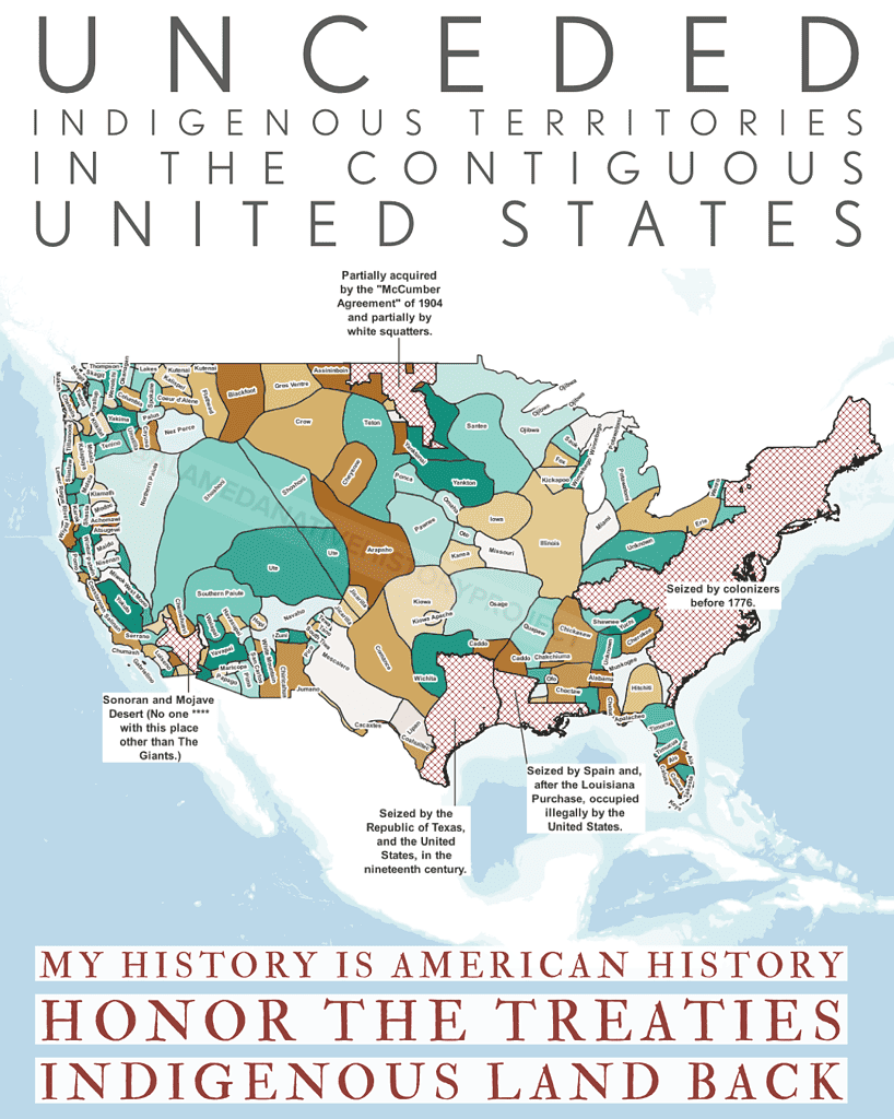
Unceded Indigenous Territories in the Contiguous U.S.
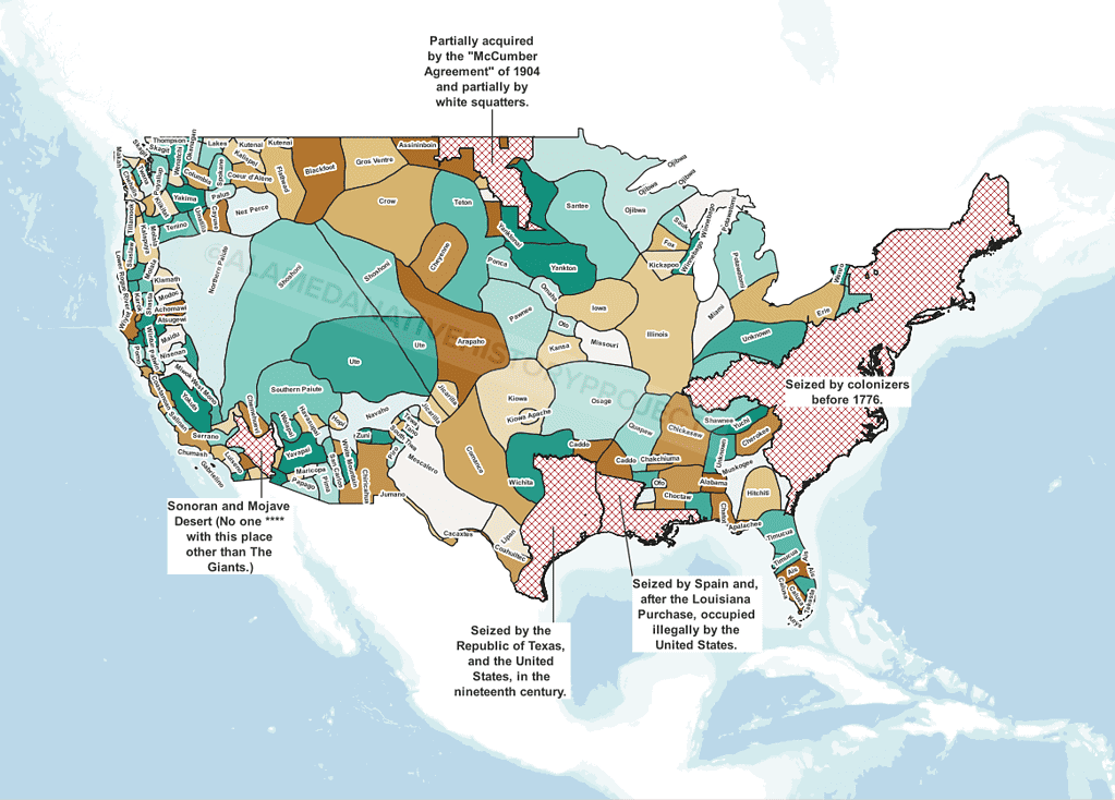
Unceded Indigenous Territories in the Contiguous U.S.
Alameda Native History Project releases a new Alameda Shellmound Map Model to show the capability of Augmented Reality, when it comes to virtual classrooms, and independent & remote learning. And to showcase the direction of education, and uses for technology, as we progress further into the 21st Century.
This map is appropriate for use in a K-12 setting; and represents the Alameda Shellmounds, as seen by N.C. Nelson. [“Shellmounds of the San Francisco Bay Region”, Nelson, 1909] This map model was created by Gabriel Duncan, and it was stylized using Adobe Aero.
Adobe Aero is a free program by Adobe, Inc., available for iOS and Android.
For more information about this model, or how to get a copy, email the Alameda Native History Project.

For the first time ever, an entirely independent research project, led by a Native American descendant, has produced a tangible representation of pre-contact Native American Spirituality and Engineering.
As a descendant of California Native Americans, adopted out of my tribe at birth, raised by white people, and growing up in a place like Alameda–which is a “good ole boy” town, and known for it’s white racist, residents, and it’s over-policing of people of color….
As all of that…
I needed more than these pretty words and vagaries.
More than a rock in the middle of Lincoln Park, in Alameda, Commemorating the Ohlone Shellmound the City of Alameda dug up and used to pave Bay Farm Road.
When public figures speak about shellmounds, they are referred to in terms of what shellmounds symbolize.
We’re given a rosy, idealized, wash of what life was like in the San Francisco Bay Area before the Spaniards and “White People” came.
It’s very light on details, but gives us just enough to sort of “dream” of what life was like.
This is all well and good if you’re not that interested.
If all you wanted was a simple answer to the question of,
But some people want to know what it looked like, really. In the sense of being able to know where things were. Being able to see what kind of plants were growing at that time (some plants and animals have gone extinct in the intervening 300 or so years.)
Where an impetus should be placed on saving those withered, orphaned pages, plastered to the back of shelves, and in the dark grimy corners of filing cabinets. Getting those pages archived, digitally. Creating new renditions of old data and information, in modern formats. In high-fidelity.
The last scribbled field notes, and crumpled photographs that are almost lost to history; but which carry the little bits and pieces glossed over by researchers who were never looking for more than statistical data, or a PhD. Or who just hunted for the citation, without bothering to read and comprehend the rest.


We need our histories, language, and secrets, to help us re-imagine what a De-Colonized Future really looks like. To help us repatriate the ancestors being returned to us from these museums and universities. And we need land back, so we can have a place to bury our ancestors, and let them rest in peace.
It was cataloged and scattered around the world, to different museums, universities, and private collections. Everything from our oral histories to our ancestors’ bodies are in pieces.
There was a time in America where white-passing Hispanic people claimed to be White, and light-skinned Native Americans pretended to be Mexican.
This was because Native Americans who were caught in public, off the reservation, could be subject to arrest–where a white man could “buy an Indian” as a slave–forced on to a nearby reservation, or just killed on the spot.
Mexicans and Spaniards were allowed agency, and relative freedom, when compared to the possibility of being criminalized and sold into slavery, or killed.
So that’s why many Native Americans declared Mexican ancestry, and took Spanish last names, or married into those families: to hide from the terror and racism Native Americans were subjected to by the American Government.
These people, with surprise ancestry, or “hidden heritage” cannot be discounted. They have been completely oblivious to their own ties to this land, and these shellmounds.
But, an awakening is happening, the veil of [necessary?] secrecy is finally being lifted.
How can we teach ourselves, and each other about what Native Land really is, without being able to visit it, or even talk about what they look like?
Examples like the diorama of the Tuibun (Ohlone) Village at Coyote Hills Regional Park, in Fremont, California, are invaluable to helping one imagine, envision or just “picture what it was like.”

Strange word, “dis-enfranchised”.
As a descendant of California Native Americans, adopted out of my tribe at birth, raised by white people, and growing up in a place like Alameda–which is a “good ole boy” town, and known for it’s white racist, residents, and it’s over-policing of people of color….
More than a rock in the middle of Lincoln Park, in Alameda, Commemorating the Ohlone Shellmound the City of Alameda dug up and used to pave Bay Farm Road.
The symbolism of shellmounds is tied to colonization, and landback, and rematriatrion, and gardens.
But what about the other shellmounds?
Every article says the San Francisco Bay Area had at least 425 Shellmounds. But these rely on the recitation of the same, stale facts. The main narrative, and recurring implication, is that, all the shellmounds have been destroyed, and there’s nothing left but three locations in the San Francisco Bay Area:
Because the mission of the Alameda Native History Project was to discover what happened to the Alameda Shellmounds; and that, of course lead to researching other Shellmound locations, I learned: of these three locations, only the shellmound in Emeryville is the correct location.
Upon closer inspection both Glen Cove and West Berkley Shellmounds exist, or existed about 100 feet away from the locations Corrine Gould has alleged, on average. Which wouldn’t be such a big deal if there weren’t huge protests and millions of dollars spent in legal battles over protecting a thing that wasn’t even there. It’s not even a masked-man fallacy. But it’s close. (Especially in West Berkeley.)
This brought about frank questions like, How come Corrine Gould is only interested in Shellmounds that are already destroyed? How come her groups aren’t interested in protecting other shellmounds, like the four at San Rafael Rock Quarry? (She went out to Miwok Territory, despite the fact she’s Ohlone and occupied Glen Cove Park, without the permission or endorsement of the real tribes who’s territory Vallejo falls in.)
Is it just easier to advocate for seizing parking lots? An open space can fit hundreds of protestors, and garner much more attention, when it’s in the middle of a city. Places like outdoor malls, and the center of a shopping district are perfect for garnering public attention. Maybe that’s why more remote mounds in places like Contra Costa and Marin county haven’t been advocated for?
Regardless of the new questions the research has uncovered, the Alameda Native History Project has a self-proclaimed mission to educate the public about shellmounds, and provide detailed, actionable information for their preservation, and protection.
As such, this project will continue to produce and release educational and research materials; to bring attention to all San Francisco Bay Area Shellmounds, and advocate for their protection.
But it’s hard to do that when the leading voice is trying to limit, or stifle the discussion about Shellmounds, to the point of providing incorrect information about their locations.
A lot of people wanted to know, “What is a shellmound? What does a shellmound look like? How big were the shell mounds?”
And, while one could spend time curating schematics, maps, and historical images there are truths which reveal themselves.
There are two Shellmound Models available. They are version 2.5, and 2.6, respectfully.
Version 2.6 is in .REAL format, which is used with Adobe Aero, a mobile-based Augmented Reality platform.
Version 2.5 is in USDZ format. Universal Scene Description is used by Pixar (among other companies); and is now a native 3D Object Format for both iOS and Android 3D Object Viewer.
These shellmound models were created for educational, and research purposes. Commercial use of this model is strictly prohibited. When featuring this model, please include the following citation:
“Shellmound Model created by Gabriel Duncan.”
| Shellmound Model v.2.5 | (download) |
| Android / iOS (.usdz) | |
| Shellmound Model v.2.6 | (download) |
| Adobe Aero (.real) | (in-app) |
Tag your AR experience on Instagram using @AlamedaNativeHistoryProject!
Send us a note, share your stories via collab@alamedanativehistoryproject.com!
You’ve probably heard that before.
While one group may be the most vocal about claiming their ancestral land, rest assured, there are other groups who claim that exact same place.
While it’s true Indigenous People shared many spaces with each other for a plethora of reasons, including mutual survival, the actual “Tribes” in the San Francisco Bay Area were formed thousands of years ago.
In spite of the fact that the California Native American Heritage Commission recognized corporations as Tribes, it’s important for you to recognize the difference between a corporation and a Tribe.
This is especially important Today; when seeking out indigenous people and tribes to consult with on various projects like land acknowledgements, cultural easements, land back, or deciding whether or not to pay into a “land tax” scheme.
Proving our Ancestry, or Blood Quantum, is a common challenge Native Americans face. It may not be right, but it’s the reason we know who our nearest Full Blooded Relative is.
Blood Quantum is an ugly, racist concept. [A tribe is made of family. That’s how tribes work.]
But it’s how we separate the Elizabeth Hoovers and Ward Churchills from actual Indigenous People.
“Who’s your grandmother?” Is one of the most common questions you get asked when you talk about the rez. We keep track of who is who. It’s not hard, because it’s such a small world. But, even if we aren’t close, we’re still native; and we still look out for each other.
If they are a Tribal Chairperson, it’s okay to ask them how long their term is, and when the next elections will be held.
If this person represents a group of tribes or villages, they should tell you which villages they represent without you having to ask.
But, the Native American Heritage Commission does not seem to vet the lists, judging by how many corporations are considered not only Tribes, but the “Most Likely Descendant” to Native American Burial Grounds and Cultural Resources.
Corporations cannot be Tribal Governments because the exercise of sovereign powers is not a charitable purpose. Sovereign powers include the right to repatriation of remains, as declared in the United Nations Declaration of Indigenous Rights, article 12.
He also did work on the Graton Rancheria; and the Confederated Coastal Miwok and Southern Pomo tribes.
But I found Milliken’s “Ethnohistory and Ethnography of the Coast Miwok and Their Neighbors, 1783-1840” on Marin Miwok‘s website. That document has a map of “Coast Miwok and Pomo Communities withing the Zone of Franciscan Mission Disruption, their Probable Locations and Possible Boundaries”. Very handy. I immediately printed it out and used it to figure out where Indian Beach is in all of this.
The changing topography of the Coasts, rising sea level, and dredging and landfill (among other things) have made it futile to argue about some places, like West Berkeley; where no one has a good idea of where the West Berkeley Shellmound actually was, despite the address of Second & Hearst given to it.
People would rather argue over the location of Strawberry Creek, and it’s accompanying marsh instead of taking another hour or two to just read the studies, and find the specific location.
Other mounds did not have the luxury of being named specifically. For instance, the Fernandez site, a shellmound situated in the Rodeo, California area, a little South-West of Martinez, California did have a partial coordinate address mentioned. But, when the coordinated are viewed, the location hovers over the waters off San Pedro Point.
There is also another mound, which was located in the bay, around where Midshipman Point is, which is just gone. No mention of whether the mound was actually standing in 1908, whether it was covered by water, or used to fill the area south of California State Route 37, where it meets the Lakeville Highway.
Furthermore, trying to rectify Nelson’s map to the shoreline of the interior of the San Francisco Bay Area was even more difficult, considered about half of the shorelines are artificial. That is: the shorelines have either been filled or dredged, and do not match the historic shorelines. This made it very hard to judge the specificity of the locations of the shellmounds mapped by Nelson.
But, by using 29 control points, I’ve managed to rectify the map to the best of my ability.