Alameda Native History Project releases a new Alameda Shellmound Map Model to show the capability of Augmented Reality, when it comes to virtual classrooms, and independent & remote learning. And to showcase the direction of education, and uses for technology, as we progress further into the 21st Century.
This map is appropriate for use in a K-12 setting; and represents the Alameda Shellmounds, as seen by N.C. Nelson. [“Shellmounds of the San Francisco Bay Region”, Nelson, 1909] This map model was created by Gabriel Duncan, and it was stylized using Adobe Aero.
Alameda Native History Project is not sponsored by, or receiving money from Adobe. This is not a paid product placement. This is an example of how to use the tools already available to you, for free, to make really cool stuff for your class or presentations.
For more information about this model, or how to get a copy, email the Alameda Native History Project.
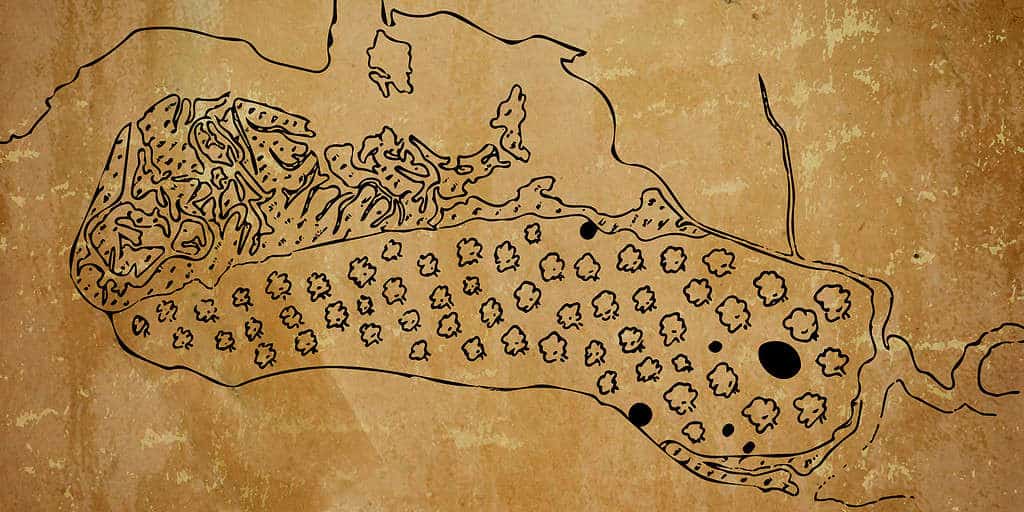
The Alameda Native History Project project presents a map of the three Alameda Shellmounds, as seen by N.C. Nelson in 1907, restored and presented in the present-day landscape.
For the first time ever, the Shellmounds of Alameda are being visualized, and presented as a physical, tangible land feature.
The purpose of this map is to:
Acknowledge that Alameda was a place were local Ohlone communities came to bury their loved ones;
Illustrate the large size and scale of shellmounds, in general;
Visualize a theoretical landscape where the Alameda Shellmounds were preserved;
Fill the gaps made by Alameda Museum’s lack of accurate or meaningful information about the First Alamedans: Ohlone People.
Created using derivatives of open-source data, including (but not limited to) USGS, NOAA, USCG, NASA, Google Earth. Analyzed, processed, and produced by the Alameda Native History Project, using open-source software available to anyone with a smart phone, and the most basic computer.
Why did the Alameda Native History Project create these maps?
Necessity
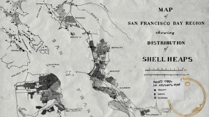
The first map created by the Alameda Native History Project was the geographicaly-conformed (or “geo-conformed”) version of N.C. Nelson’s historic 1909 Map of the San Francisco Bay Region Showing Distribution of Shell Heaps. This 20th Century version of Nelson’s map was painstakingly converted, and conformed, to 21st century Geographic Coordinate Systems.
Geo-conforming Nelson’s map made it possible to accurately plot the coordinates marked on Nelson’s map; and perform Present Day Observations of the Bay Area Shellmounds.
The San Francisco Bay Area Shellmound Map now has over 300 confirmed locations. The accuracy of this map has improved considerably over time; and the research version is now accurate to within 100 feet.
This was because maps like those featured by the Stanford University’s Spatial History Lab were little more than photocopies of the original coastal surveys, with graphic overlays.
While this might be impressive to some, the lack of any real functionality or new information derived from this kind of exercise was underscored when I tried to find/use this information in the context of the Shellmounds of Alameda.
Stanford University, Spatial History Project1909 N.C. Nelson Map of the San Francisco Bay Region Showing Distribution of Shellheaps
This made it necessary to recreate a map of the historic shoreline of the San Francisco Bay Region, and hand-plot more than 300 shellmounds, just so I could view these maps and take screenshots of them to share with you. All in an effort to show you where the Shellmounds of Alameda are.
Clarity
Reproduction of Whitcher’s Survey.
The same geo-conformance process was applied to an historic map of Alameda, which has become the Alameda Museum’s sole reference concerning the shellmounds of Alameda: Imelda Merlin’s “Alameda: A Geographical History”. This book is a Geology Master’s Thesis, by Imelda Merlin, who lived and died in Alameda, California.
The fact that Merlin was an Alameda resident; and that Alameda Museum owns the copyright to the book should be immaterial to the generally dubious nature of a photo-copied map, with hand-drawn notations.
In spite of the fact that Imelda Merlin was a student at the University of California, Berkeley, it appears that the most relevant information created by N.C. Nelson–for the archaeology department of the same university–was avoided altogether by Imelda Merlin in her work.
For the aforementioned reasons, it was determined that Imelda Merlin’s work merited careful scrutiny and interrogation.
Because, at this point, I already had two other sources of location information compiled for the Alameda Native History Project:
1. Public Records Aggregate
Any mention of Alameda Shellmounds in the following archives/libraries/collections:
All references to the Alameda Shellmounds at the Alameda Free Library:
this includes references in the Historic Alameda Newspaper Archives, and the “Alameda Historic Reels”;
as well as Clipping Files, Alameda Historical Society Card Catalog [Defunct];
Library Catalog, and Special Collections.
Online Newspaper Archives, Indexes
Online Finding Aids
Genealogy Websites, National Archive, and More.
References were logged, and copies of the documents were saved. Then the documents were analyzed, information was extracted, and processed to produce an aggregated list of locations of the Alameda Shellmounds–according to explicit references in these sources.
Then the locations were geocoded, and plotted to create a map that … I don’t even know what to call. “Shellmounds Mentioned in the News”?“Historic Shellmounds”?
“Public Records” is not a very attractive label; but it might be the best label for that layer on the Alameda Shellmounds Map. [So, in case you ask “What is the Public Records Layer on the Alameda Shellmounds Map”, now you know.]
2. Nelson’s Map of the SF Bay Region Shellmounds
Like I said, this was the first map I painstakingly recreated. So, therefore, I had the locations Nelson marked within Alameda.
When I analyzed the base map printed in Imelda Merlin’s book, I was able to use these sources to help conform Merlin’s base map with current Geographical Coordinate Systems, so I could plot the positions marked in the Imelda Merlin layer in the Alameda Shellmounds Map.
I used innumerable copies of maps, surveys, photographs, and other visual representations of Alameda, from 1880 to 1910 to help conform the “Whitcher Survey” referenced in Merlin’s Map. I was never able to find a true copy of the “Whitcher Survey”. The survey is not at City Hall–as Merlin’s book states–or in the Alameda Free Library. The Museum did not have it, at last check.
I also looked to see if any map copy provided by the official website of a University, or Government Institution, or the publisher itself, or a credible archive, actually included similar shellmound positions during the time Merlin’s map was created.
TL;DR: they do not. Not even the Land Grant Case Maps, or the legit Combined, Drafted, or Official Coastal Surveys of that time, have even a hint of a shellmound anywhere. (I even tried to find a copy of the coastal survey used in a well-known documentary about the Shellmounds of West Berkeley, but was unable to track down the file before publication.)
However, even though Merlin’s map diverges from the Official Historical Record, she did capture something in her hand-drawn sketch: all of the dots on her map correspond to places where Ohlone graves have been found.
In spite of the fact Merlin calls the First Alamedans “Miwok”–instead of Ohlone. In spite of the fact that Merlin doesn’t even mention the map in the actual narrative (or “text”) of her book. In spite of the fact that the map was published in her thesis (which was then published a few years later, in a book) without any references, or citations–aside from the coast survey base map.
Somehow, she manages to highlight the same places I have located using mentions of Ohlone graves and Native American remains found in historic Alameda newspapers. Many of these discoveries happened decades after the publication of Merlin’s work. …Which could indicate that these discoveries are coincidences, rather than correlations.
It makes sense that the discovery of human remains would be carefully guarded; only mentioned in whispers between Alameda insiders, and related professionals. Certainly, the newspaper would be encourage to leave anything like that out. … At least until the houses were sold.
It’s not hard to have editorial control when real estate companies were the primary revenue sources for local Alameda newspapers. Furthermore, the Redline wars in Alameda were brewing long before residents voted to approve Measure A, in 1973.
In a “closed”, racist, housing economy, where BIPOC are excluded, and declining property values could be caused by even a whisper of non-white interest in a neighborhood: the prevalence of bones underfoot could undermine the appeal of an entire city.
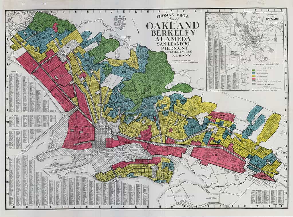
Historic Redline Map showing Oakland, Berkeley, and Alameda
Alameda was probably a place where the surrounding Indigenous communities would come to bury their dead.
When you take into account historic newspaper articles like the one below (from 1893;) and the preponderance of subsequent articles concerning Native American Graves and Remains found, and then plot those locations into their own map, you get a layer of “Remains & Relics Found”.
While it is the Euro-Centric imperative to determine a single point; and explicit boundaries: the size and nature of the shellmounds was as much a mystery to these colonizers as it is to us today. For different reasons though.
Early anthropologists, archaeologists, and ethnologists lacked the imagination necessary to make the logical leaps necessary to recognize the purposefully obscure nature of our infrastructure, or decode the metaphors we left in notes and drawings for our friends.
Because of this, and because white people destroyed as much of our stuff that they possibly could (on purpose [I don’t know why]), we are now–in many cases–left with the remnants of remnants.
Because the records concerning these events, and the mere existence of the massive burial grounds under the City of Alameda, and the cities of the rest of the San Francisco Bay Region have been actively concealed, and suppressed, this story has remained untold.
“Alameda’s Indian Mounds“, published in The San Francisco Examiner, on Sunday, March 26, 1893:
“When the progressive Alamedan decides to build a home of his own on a section of the encinal that have been allotted to him by his favorite real estate dealer…
“He does not order work suspended when the excavators, who have undertaken the task of building his prospective basement, run across a well preserved skeleton or turn up a hideous looking skull.
“He has become used to such things and he knows…
“in all Alameda there is scarcely a square yard of ground that does not harbor the crumbling remains…”
The pieces of the puzzle can still be found.
And so, Nelson’s Map, Merlin’s Map, and the Public Records map were offered as three separate layers of the Alameda Shellmounds Map; so that you may also discover and analyze the similarities and differences between the locations, yourself.
The other layers mentioned, such as “Remains & Relics Found”, and more are also available to view using the layers panel of the Alameda Shellmounds Map.
As our records continue to grow, and new information found, the map and this site continue to grow as well.
Aesthetic & Availability
Let’s face it: no one wants to look at nth generation copies of copies.
I don’t know about you, but I’m tired of trying to squint, and adjust brightness, contrast, and gamma until I can barely almost read the most important part of this chapter….
I want to look at a webmap of the San Francisco Bay Area Shellmounds. I need my experiences to be more interactive, and offer more than an empty citation to a book I can’t even find anymore. I want to see a scan of the book. And read the citation myself.
But even that’s not enough. I find myself getting triggered by the language of these old, dead, white men that I just want to fight.
Most of these narratives are written from an all-white perspective, often using racial slurs, and offensive descriptions. For the past 74 years, the Alameda Museum has furthered the “gentle savage” myth that permeated Victorian Era culture in America. And continues to push the idea that Ohlone people just disappeared from Alameda, and the Bay Area, entirely.
It’s been the same narrative since “time immemorial”. (Even that phrase is from a white-washed narrative meant to pander to a White Gaze that isn’t even a majority anymore.)
California History, when it comes to Indigenous People, is broad, at best. Very little space or effort is given to properly naming, or describing Native Americans, how they looked, where they lived, what they ate….
Most textbooks will even allude to American Indian relationships with White People as something symbiotic; and leave this chapter of history conveniently blank, to make room for the concept of Manifest Destiny.
The history that we are being taught has specifically avoided the policy of indigenous extermination enacted by a California Governor in the late 1800’s; California’s military support of Indian Wars in Oregon in the early 1900’s; or, how Los Angeles stole water rights from Tribal Nations in the Central Valley and has helped to destabilize the California ecosystem, with devastating effects.
We are not taught about this.
We have instead been dazzled by trains, bridges, and pretty houses with gardens, like babies with a ring of keys.
California is the most diverse state in terms of Tribal Nations, with over 300 Indigenous Languages Spoken in California, alone. We are astronomers, conservationists, artists, engineers, doctors, and so much more. Our stories and contributions matter.
Ohlone people still live in the San Francisco Bay Area. The Muwekma Ohlone Tribe of the San Francisco Bay Area could use your help in fighting for federal recognition.
The Native American, Indigenous People that you speak of like they went extinct in the 1800’s; those people are my great-grandparents.
The first step in justice for Indigenous Californians is recognizing us.
This is why it’s important to update the aesthetic of Historical Curation, and Exhibition Design, to utilize the tools we have in the 21st Century to reach learners everywhere, using the interactive multimedia methods they use and engage everyday.
“Alameda Museum: / If you won’t share our history, give our artifacts back / Celebrate the First Alamedans just / as much as your Colonizer Heroes. / Alameda’s Racist History” Title art for @AlamedaNativeHistoryProject on Instagram.com.
Alameda is a model colonial city. Their Victorian houses, and expansive gardens have been written about for hundreds of years. Regular Alameda Garden Tours, and Alameda Legacy Home Tours extoll the virtues of Alameda’s First Colonizers.
These historical celebrations routinely leave out facts, such as,
“This garden was fertilized by using human remains found in one of Alameda’s three shellmounds.”
Or,
“This sidewalk was constructed using one of the over 350 Native American bodies found in the ‘Sather’s Mound’.”
The Alameda Museum is exclusively devoted to commemorating and memorializing Alameda’s White History, while simultaneously ignoring and minimizing the existence and contributions of people of color; and the atrocities committed by those who are purported to be such heroic goliaths of Alameda History, today.
This is all done in the shadows of people like Rasheed Shabazz, someone who had to trace his own Alameda Legacy to bring us Black Alameda History, which was never touched upon, or even considered by an all-white museum staff, and curation team. [
Sure, the Alameda Museum invites us to search their archives. But the word “search” belies the onerous nature of digging through files and card catalogs which aren’t actually indexed or organized in any useful way.
People always offer us the chance to do their work for them, like it’s a favor to us.
But let’s be clear: an archive that isn’t indexed or organized is trash.
The real issue here, is that the Alameda Museum has existed for so long without ever: (a) indexing their holdings; (b) focusing on anything other than Alameda’s White History; or (c) ever asking for permission to possess the Native American Funerary Objects, and Grave Goods in their possession….
The issue of Alameda Museum’s possession of Native American Grave Goods and Funerary Objects is especially salient considering their absolute lack of respectful handling of the Historical Events Surrounding the Sather’s Mound, and the Destruction and Morbid Uses for Alameda’s Shellmounds.
Simply put;
Alameda Museum, if you’re not going to engage the Muwekma Ohlone Tribe, ask for permission to possess their artifacts, and present respectful, and responsible, information regarding the First Alamedans: then you don’t deserve to possess their artifacts.
After studying maps, and reading literally thousands–maybe tens of thousands–of pages about the First Peoples of the San Francisco Bay Area; I’ve learned a lot.
It took a while to read works from the beginning (1800’s), up to the latest, including Randall Milliken’s work; which goes beyond the 2009, “A Time of Little Choice”.
He also did work on the Graton Rancheria; and the Confederated Coastal Miwok and Southern Pomo tribes.
But I found Milliken’s “Ethnohistory and Ethnography of the Coast Miwok and Their Neighbors, 1783-1840” on Marin Miwok‘s website. That document has a map of “Coast Miwok and Pomo Communities withing the Zone of Franciscan Mission Disruption, their Probable Locations and Possible Boundaries”. Very handy. I immediately printed it out and used it to figure out where Indian Beach is in all of this.
This map was really hard to conform using present-day landmarks.
Not only has sea-level risen considerably in the past 112 Years; but much of the coast line noted in the Coastal Survey has eroded, or used as fill, to erase much of what was open water along the San Francisco Bay Area Shorelines.
This is something that was especially noted in later studies of Bay Area Shellmounds: the possibilty that a mound which had been observed in 1908, was probably lost to the sea by erosion, before the 1970’s and 1980’s.
The changing topography of the Coasts, rising sea level, and dredging and landfill (among other things) have made it futile to argue about some places, like West Berkeley; where no one has a good idea of where the West Berkeley Shellmound actually was, despite the address of Second & Hearst given to it.
People would rather argue over the location of Strawberry Creek, and it’s accompanying marsh instead of taking another hour or two to just read the studies, and find the specific location.
Other mounds did not have the luxury of being named specifically. For instance, the Fernandez site, a shellmound situated in the Rodeo, California area, a little South-West of Martinez, California did have a partial coordinate address mentioned. But, when the coordinated are viewed, the location hovers over the waters off San Pedro Point.
There is also another mound, which was located in the bay, around where Midshipman Point is, which is just gone. No mention of whether the mound was actually standing in 1908, whether it was covered by water, or used to fill the area south of California State Route 37, where it meets the Lakeville Highway.
Furthermore, trying to rectify Nelson’s map to the shoreline of the interior of the San Francisco Bay Area was even more difficult, considered about half of the shorelines are artificial. That is: the shorelines have either been filled or dredged, and do not match the historic shorelines. This made it very hard to judge the specificity of the locations of the shellmounds mapped by Nelson.
Nelson (1909) Map, rectified to Present Day Map of San Francisco Bay Region.
But, by using 29 control points, I’ve managed to rectify the map to the best of my ability.
First post. And a definition of the concept of an, “Urban Reservation”.
The Urban Reservation, to me, is a place that can be quickly defined as analogous to the American idea of the “ghetto“. The distribution of ethnicity is unimportant; the defining point is that these areas do not offer enough food [external], jobs, or services (ranging from water & sanitation, to healthcare.)
Let’s be clear, though: American Ghettoswere created by Redlining, Segregation, “Black-listing”, White Flight, just… rampant racism.
Other forms of ghettos exist. Some rural areas closely match the defining properties of ghettos. The only difference is that these areas suffer because of low population density–State and Federal funding is usually allotted by population; therefore, less populated areas receive less funding. Smaller populations also do not attract large corporations. Industry in rural areas is generally mineral, and agriculturally based; and introduces pollutants, and negatively impacts community and environmental health in myriad ways.