
Fully updated, featuring new historic wetlands, shorelines, and more.
Available exclusively at the Alameda Native History Project.
Find it on our website:
NativeHistoryProject.org > Maps > Alameda Shellmounds Web Map
NativeHistoryProject.org > Maps > Alameda Shellmounds Web Map
All juxtaposed against the modern day landscape to provide accurate scale and positioning.
Available in several sizes.

Because of the juxtaposition of the historic peninsula with it’s present day silhouette, it is much easier to see which parts of Alameda were physically connected and formed the peninsula more recently known as the “Encinal”.
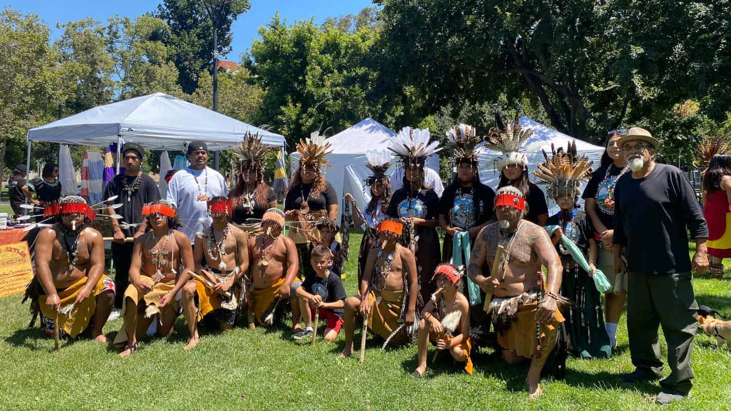
Both Alameda and Oakland are in a region referred to as Xučyun (also known as “Huchiun”.) Xučyun is part of the ancestral homeland of the Muwekma Ohlone Tribe of the San Francisco Bay Area. Muwekma have lived in the Bay Area for over 10,000 years.
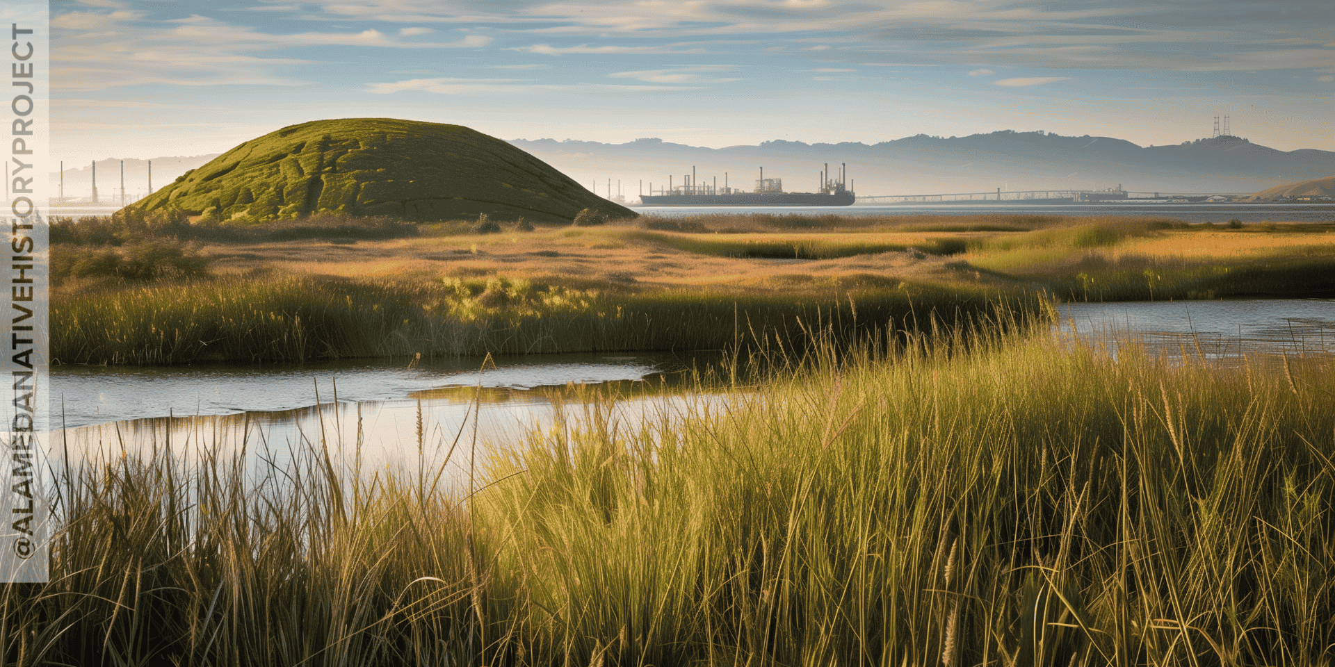
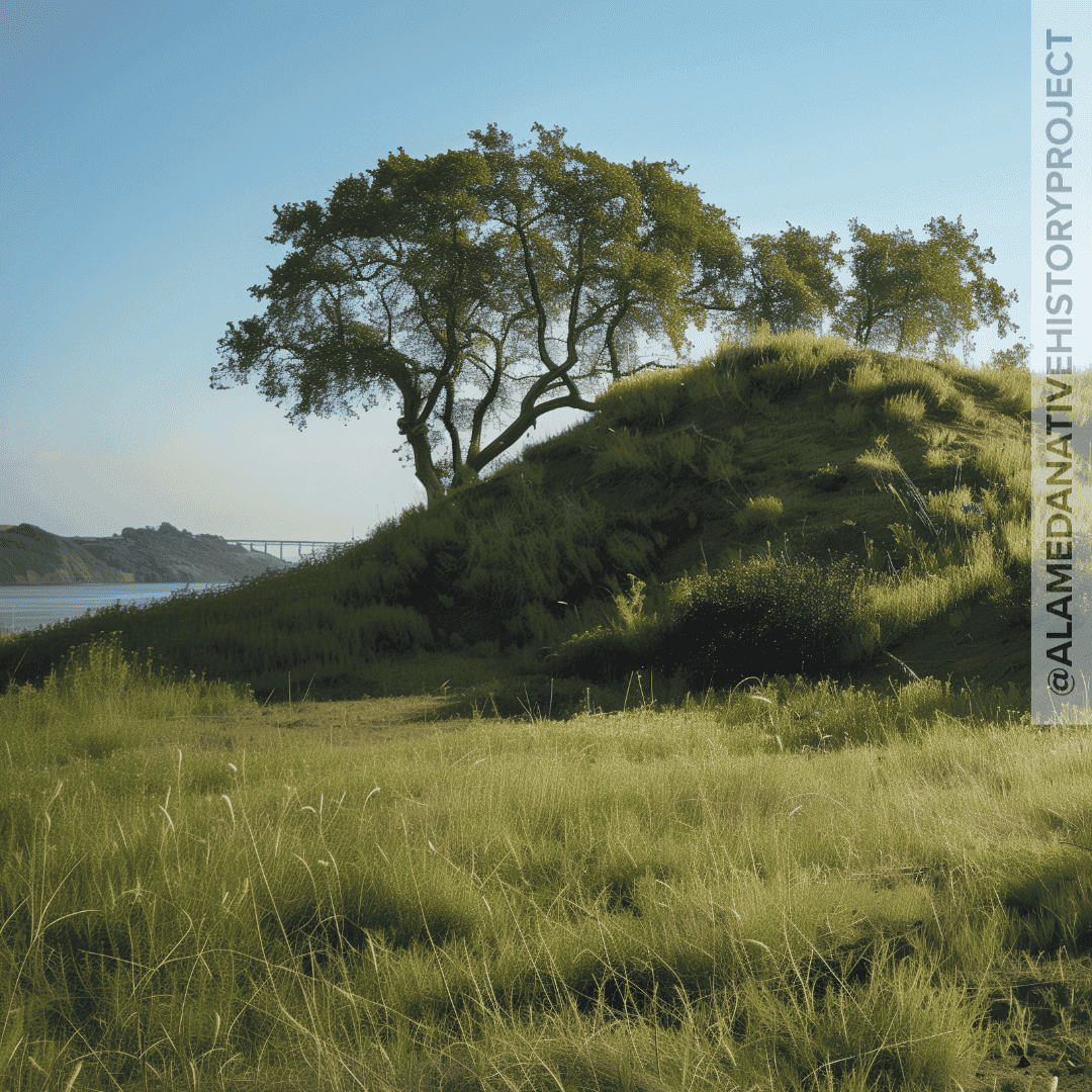
For the first time, all four of the Alameda Shellmounds have been put onto one map. Most people only know about the shellmound on Mound Street. But there are more shellmounds, in Alameda. There were over 425 shellmounds in the Bay Area. Including Alameda’s largest shellmound, at the foot Chestnut.
See also: Shellmounds – What Are Shellmounds?
This place we call Alameda was once called “La Bolsa de Encinal”. Meaning, “the Encinal forest”. Because the peninsula was host to a verdant, “ancient”, Live Oak forest. (The forest still exists. It just looks different.)
Many of the first accounts of the historic peninsula use rather idyllic, and paradisaic language to describe the rich pre-contact ecosystem that thrived here.
Alameda was once referred to as a “Garden City”. This is the place where the Loganberry was supposedly born.
tl;dr : Everyone wants to know where the landfill is. [There! I said it, okay?] They don’t even really care where Alameda used to be connected to Oakland. Or about the ancient whirl pool in la bahia de san leandro. But, whatever.
Look closer, and you can see the footprints of present day buildings. That’s the landfill.
For real though, I made this layer using pre-1900 shoreline vector data I compiled for the Bay Area region, and stitched together.
In Version 1, I made a kind of sloppy polygon with historical shoreline vectors, and painted it green. It was a good placeholder for the historic marshes and wetlands of the Bay Area.
Version 2 features the finely detailed historic wetlands layer created for the Bay Area Shellmounds Maps. It features very precise cut-outs for historic creeks, channels and waterways; and features full-coverage of the Bay Area region.
If you want some actual historical eco-data, check out the San Francisco Estuary Institute. They have some brilliant historical ecology GIS you would probably love, if you’ve read this far.
The Alameda Shellmound Map, Version 2, is ground-breaking in its completeness and exquisite detail.
Printed in vivid color, on premium paper. Purchase through the Alameda Shellmounds Map square payment link. 10% of all proceeds from Alameda Shellmounds Map sales go to the Muwekma Ohlone Tribe of the San Francisco Bay Area.

[Footnote: Imelda Merlin mentioned numerous shellmounds in her Geology Master Thesis, but none of her assertions were backed up with any relevant citations. And geology is not archaeology, ethnology, or anthropology, the areas of study that normally concern themselves with Tribal Cultural Resources like shellmounds.
Furthermore, the famous “Imelda Merlin Shellmound Map” was actually a map of Live Oak trees present in Alameda at the time Merlin wrote her thesis (in 1977).
The “Map of Whitcher’s Survey of ‘The Encinal’ in 1853. In Alameda City Hall.”, cited on page 104 of Merlin’s thesis, has never been found by Alameda City Hall, the Alameda Free Library, or the Alameda Museum.
Certainly this means Imelda Merlin has failed to meet the burden of proof required for institutions like Alameda Museum to take reliance upon her claims re: Whitcher’s Survey, and locations of any mounds. Yet, somehow, Merlin’s geology thesis was Alameda Museum’s sole reference regarding shellmounds. (For years Imelda Merlin’s geology thesis was viewed as the authoritative source of information about Alameda shellmounds.)]
One of the ways Alameda Native History Project decolonizes history is by interrogating the record. This means tracking down and reading citations. Critically evaluating reports and studies for bias. And calling out poor research, and prejudiced conclusions for what they are.
We decolonize history by updating the maps and diagrams of our past. Producing accurate, fact-based educational and reference materials to replace the biased and inaccurate educational products–which are still misinforming our schoolchildren and the greater public today.
By providing a more nuanced and comprehensive perspective; and doing away with the old, over-copied handouts from decades past: we are able to shed the misinformed, and racist, stereotypes and quackery that typify generations which brought us things like: “kill the indian, save the man”, Jim Crow, and “Separate But Equal”.
We vigorously challenge the cognitive dissonance of so many California Historians, asking “Where did all the Indians go?”, at a time when the entire United States had declared war on Native Americans. … Including the first Governor of California, who called for “war of extermination” against California Native Americans.
These ideas, stereotypes, attitudes, and beliefs have managed to propagate themselves time and time again in the textbooks and lesson plans used to “educate” countless generations of Americans.
👉🏼 Your purchase of the Alameda Shellmound Map supports our mission of decolonizing history. 🙌🏼
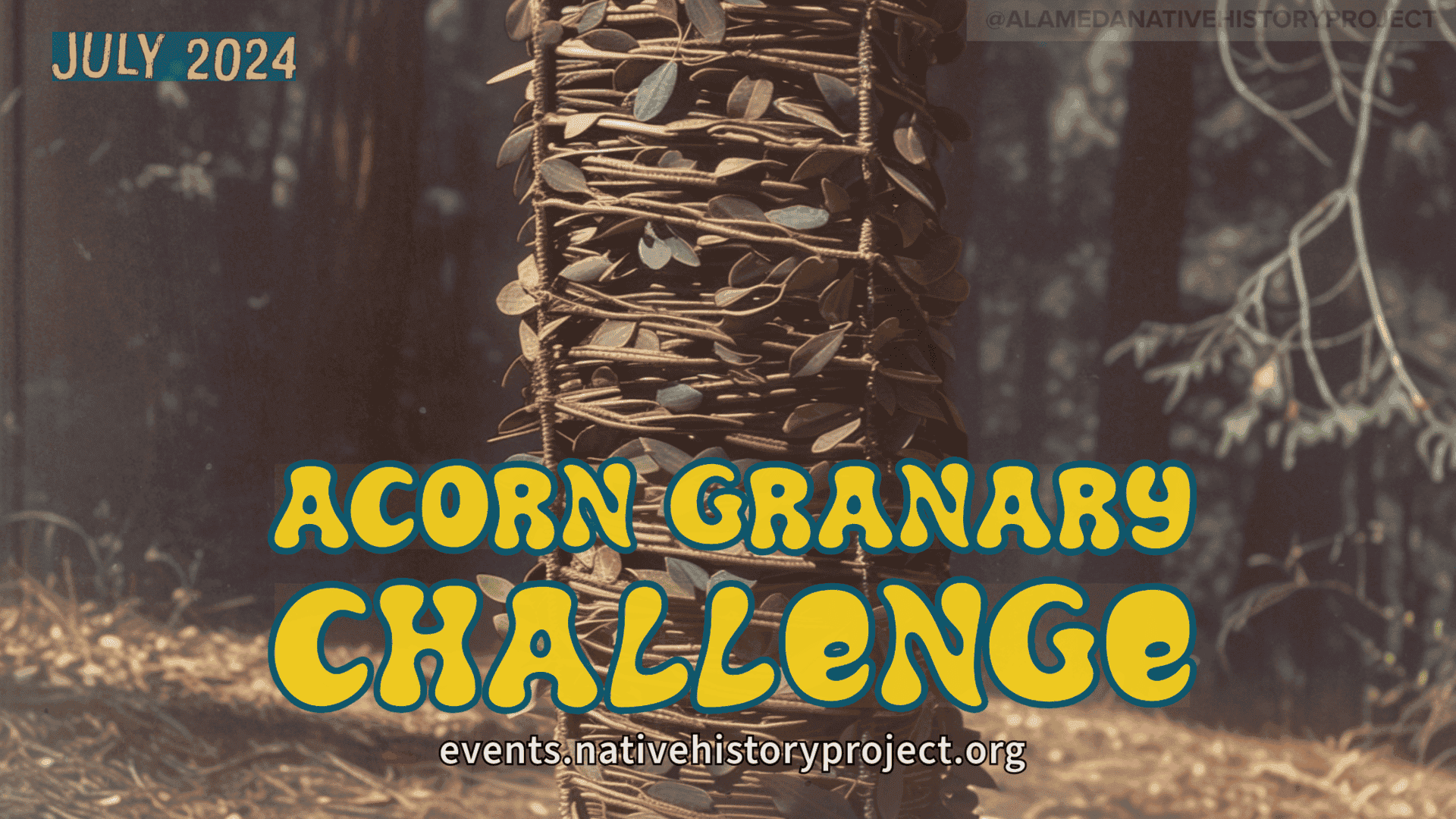

Acorn Granaries are traditional
California Native food storage systems.
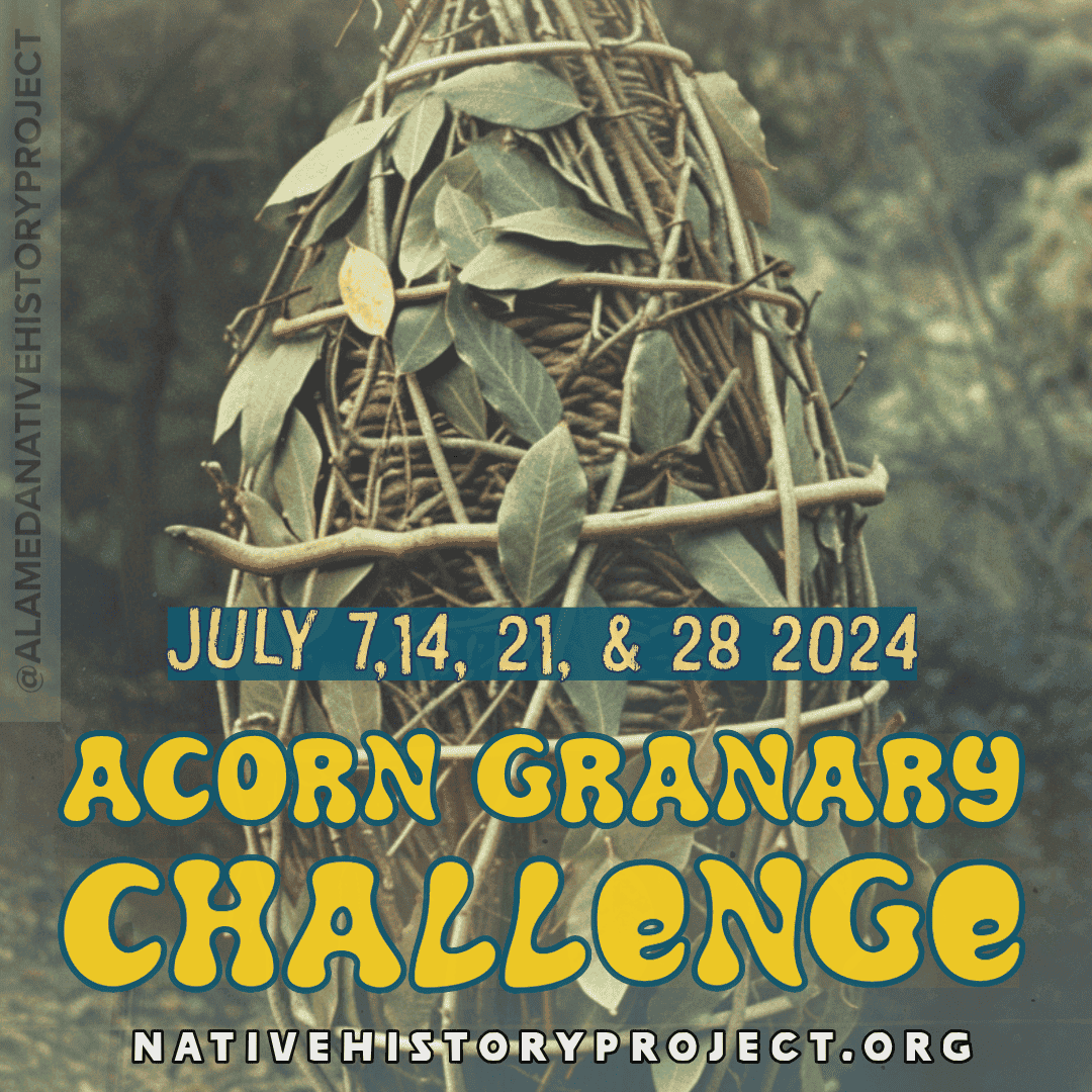
Each week will have a different focus, as we move through the steps of Acorn Granary Construction, and preparing for the harvest.
From splitting willow to making various cordage, and thatching wild grass: We will work with a mix of materials old and new. And also address the non-native plant and their uses in construction and pest management.
Most of the material gathering will take place at the Indigenous Land Lab, and the processing of cordage, thatching of wild grasses, and splitting willows will happen in town, during the Granary Construction.
This is meant to be a very mellow and open-ended process that frankly invites a little bit of creativity, and welcomes a contemporary breath of fresh air.
And we’re also open to this process taking longer than a month.
This is why we’re creating the granaries now: So we can harvest, sort, and pack our acorns into these granaries as efficiently as possible.
But, we also want to give ourselves the greatest chance of success by using multiple granaries of varying construction materials and methods. This will also give us some data to analyze and use to plan for next year!
Visit the Indigenous Land Lab Page, or email collab@nativehistoryproject.org!

This is an excerpt of an email to the Indigenous Land Lab mailing list.
Collecting as much materials for Acorn Granary construction as possible.
There are other, more serious plants, like stinging nettle, which I would like to take the time and make some cordage from. Just like splitting the willow reeds to make strips for weaving the granaries.
Hard-to-find materials would be redwood bark–which would be nice to use on the outside of a granary. And then Pine Sap–which simply won’t be readily available until later, and will require some travel into higher elevations to gather.
If you would like to help gather more natural materials for Acorn Granary Construction, please sign up for the Indigenous Land Lab Email List, to help plan what dates and times work best to plan a meet-up to harvest materials.
You are invited to participate in any or all aspects of planning and working. We’re assuming tilling should happen sometime in August.
We’ve received a lot of interest, support, and some very generous donations of equipment, supplies, and money! (All donations are tax deductible!)
We managed to find a roto-tiller we can use when we’re ready!
Some of these things we know we can borrow, like a post driver. But other stuff–like shovels and rakes–we need to keep on hand.
Luckily, we don’t need a large amount of anything other than Silage Tarp, Chicken-Wire, and Compost.
Join us in harvesting Willow, Bay Leaf, and Nettle for granary construction.
Donate tools: If you have some tools, supplies, or equipment on this list, we can pick it up. If you have a truckload of compost, we can meet you at the land lab for a drop off.
Purchase directly from our wishlist. Indigenous Land Lab Wishlist is available here.
Donate to the Alameda Native History Project. Tax deductible donations can be made to the Alameda Native History Project here.
Alameda Native History Project is fiscally sponsored by The Hack Foundation (d.b.a. Hack Club), a 501(c)(3) nonprofit (EIN: 81-2908499). Any monetary donation, or donation in-kind is tax deductible, and you will receive a donation receipt whether you want it or not. LOL. I mean, if you say no, then we won’t, but who doesn’t like a small write-off?
Anyway, it’s Pride Week, so things are totally hectic as I volunteer for the Gay American Indians. Check out the attached fliers for GAI events. Consider marching with Gay American Indians at Pride!

Yours truly,
Gabriel Duncan
via collab@nativehistoryproject.org
To join the land lab, email collab@nativehistoryproject.org, or use the form below.
Indigenous Land Lab
Mailing List Sign-Up Form
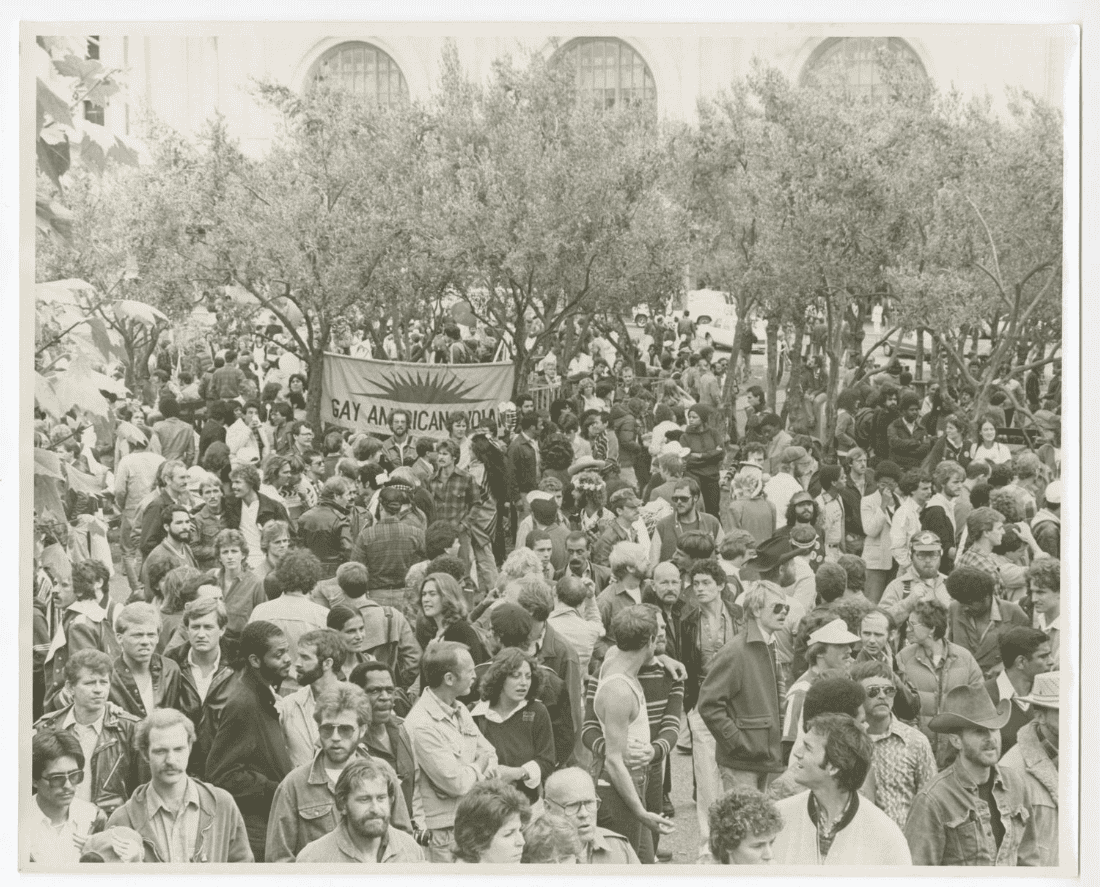
This year’s (2024) theme is “Visibility is Our Essence“.
What’s more, homophobia and learned anti-traditional behavior on reservations across Native America helped form a mass exodus of LGBTQ Native American people from their homelands, into the cities.
Because of the discrimination and ignorance both at home, and in the Castro (and other cities), LGBTQ Native American people suffered from depression, and languished from being kept out of and separated from the social support networks enjoyed by our white gay counter-parts. This situation only compounded a suicide and substance abuse epidemic–which started soon after the Relocation Act (of 1956), and still plagues our communities today.
Just because we were weren’t let into businesses and bars on the Castro certainly did not mean we were spared from “Gay Diseases” like, AIDS–which ravaged the Gay American Indian community. In fact, the AIDS Epidemic hollowed out the Native American LGBTQ community worldwide.
And, the ignorance and homophobia surrounding the virus created an impenetrable stigma which resulted in the unnecessary pain and suffering, and indignities seen across the Gay Community, but which profoundly Two-Spirit People in their own Native American communities–some of which would not let their own relatives be buried in their own cemeteries, on their own homelands.
This is in stark contrast to the fact that only 64 out of 100 Native People living with HIV/AIDS were “virally suppressed”–meaning: taking medicine to stop the viral replication process, to become undetectable, or “untransmissible”.
The other 36% of people who are not on medicine may not be at fault. They may be part of the 20% that doesn’t even know they’re infected; they may be unable to receive the care they need because of stigma from within their rural healthcare communities (which I have experienced first-hand) or because of the myriad barriers to gaining access to, and retaining, HIV/AIDS care and treatments.
The amount of research The lack of testing & research done on the prevalence, rates, and effects of HIV/AIDS on Native American People and Communities means that most Health & Service Agencies are blind to the true extent and impact of the epidemic on our friends and relatives. This issue became front and center when, in 1987, the late Jodi Harry became the first Native (that we know of) to be diagnosed with HIV/AIDS. [Harry would later take his own life.]
At that time the CDC did not keep track of HIV/AIDS diagnoses or deaths in the Native American Community. But that did not stop GAI from taking care of its own members. And, when male GAI members were too few or too sick, it was the sacrifice and service of our sisters, like Barbara Cameron, which helped us through one of the darkest chapters in Gay American Indians history.
… Refers to Native American people who do not fit the Western/European idea of what Men and Women are, and what their roles in society should be.
[The whole premise of this first sentence is offensive to Native American people because we honestly don’t care what white people think of us. And, it’s for the very reason that all People of Color have been disregarded, or all together regarded as a monolith, that has led to countless inequities in every facet of our existence in society, from healthcare to sports. In fact, the consideration and explanation of People of Color by people who treat mayonnaise as a spice, and consider the sun an enemy has never really worked out for us, at all.]
The term “two-spirit” came about as a preferred moniker to the term “berdache“–which is a french slur meaning “boy whore”–and is widely offensive to LGBTQ Native American People from a diverse plethora of tribes, communities, and backgrounds–and especially Lesbian Women, and people Assigned Female At Birth (AFAB.)
Because of the work the Gay American Indians did in bringing forth their research, and the opinions of researchers like Will Roscoe, Paula Gunn Allen, Maurice Kenny, in the first Gay American Indians Anthology: “Living the Spirit”….
… And comments and narratives from Two-Spirit People like GAI co-founders Barbara Cameron, and Randy Burns; Erna Pahe; and people like notable activist and Tribal Law Expert Clyde Hall during the 1993 American Anthropological Association Annual Meeting….
If you are a GAI Member, or are an archivist, photographer, or someone who has articles, photos, recordings or other things which you think will help us tell the story of the Gay American Indians’ 50 Year Legacy, please reach out to us directly so we can arrange a time to talk about your collection/item.


There is land for a lab. With amazing potential. There are seeds. And water.  We are ready to begin.

"All the flowers of all the tomorrows are in the seeds of today."What a great place to start. This is exciting.
Bring gloves, a hat, and your waiver. LOL. (No, for real, it’s for our fiscal sponsor.)
We’ll provide water, some shade, and (hopefully) lunch during official workdays. (At least snacks!)
https://forms.gle/zCe8ab5VnPwQDJYMA
The first, of course, would be by donating landscaping & gardening equipment you no longer use. But, we would be especially grateful for the use of your walk-behind “brush mower”, “brush hog” or “rotor cutter”.
The land we have is wild, and untamed. It’s overgrown with invasive grass, some hemlock, and a random shrub or two. This is why our list sounds more like a fire crew equipment list than what you’d expect for an established garden.


Alameda Native History Project donation link.
Alameda Native History Project is fiscally sponsored by The Hack Foundation (d.b.a. Hack Club), a 501(c)(3) nonprofit (EIN: 81-2908499). As such: all donations you make are tax deductible.
May 4th, 2024
11:00 AM to 2:00 PM
Corica Park Golf Course Clubhouse
1 Clubhouse Memorial Road, Alameda, CA 94502
Tickets: $15
-Limited Sponsorships Available-Proceeds from ticket sales go toward venue rental, lunch (and refreshments), future programming, and operations.
All donations are tax deductible.


We’d like to thank Greenway Golf, and the Corica Open Space Project, for providing our meeting space at the Corica Park Golf Course Clubhouse.
The Corica Park Open Space Project is devoted to building community by expanding access (for everyone) to the open space Corica Park occupies and sustains, creating opportunities that drive the success of our future leaders, and positively impacting friends, neighbors and community members. We are excited by all of the amazing opportunities presented by this community initiative and cannot wait to participate in, and offer you more activities and events to come!
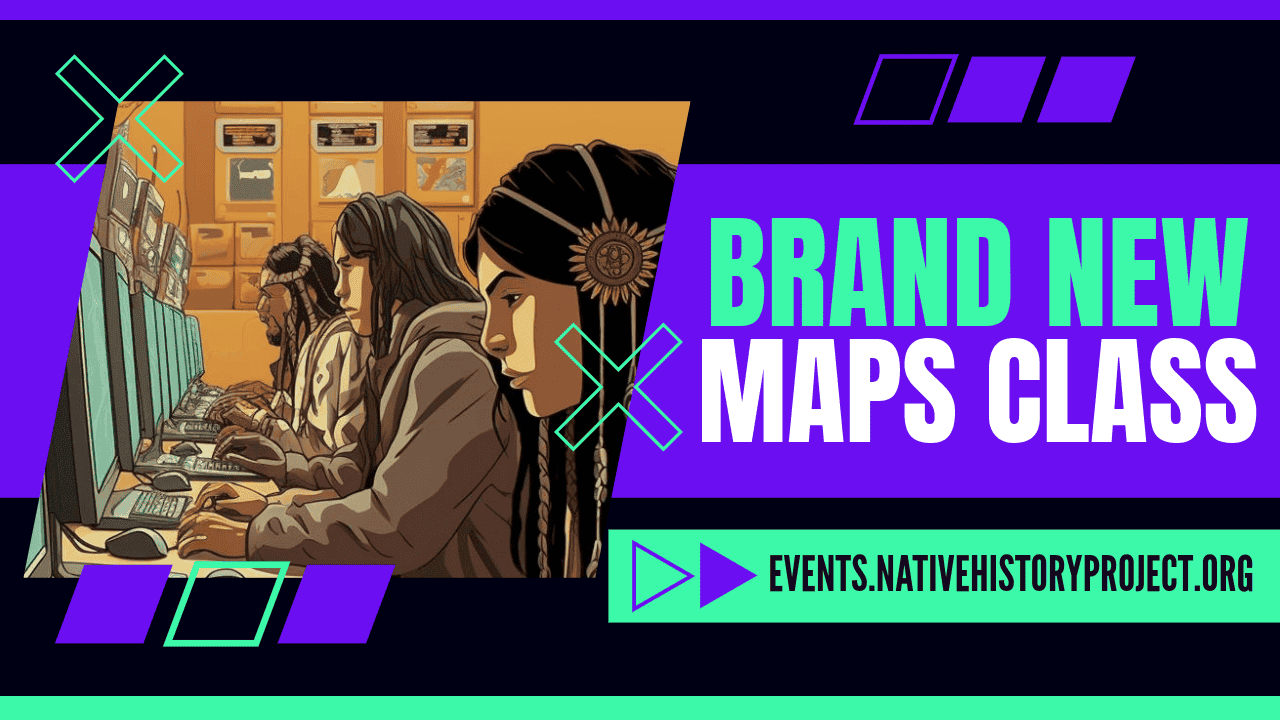
We’d also like to thank ABM Computers for their donation of computer hardware to the Alameda Native History Project. This equipment will help us ensure that everyone has an opportunity to develop their maps skills through hands-on learning experiences.
We also want to acknowledge that your donations, and the proceeds from the Indigenous Bay BART Map sales have made it possible for us to do this.
Thank you for your continued support, can’t wait to see you at our Maps Class.
For more information on how to obtain a scholarship, or how to sponsor someone, please reach out to us directly at collab@nativehistoryproject.org.
Alameda Native History Project is fiscally sponsored by The Hack Foundation (d.b.a. Hack Club), a 501(c)(3) nonprofit (EIN: 81-2908499)


Despite the fact that shellmounds are cemeteries, hundreds were still destroyed all around the Bay Area.
And–to make matters unimaginably worse–the bodies inside were ground up, and used as overspread to level out train tracks, and build massive infrastructure (like the Angel Island Immigration complex.)
Even though some news stories feature witnesses who described bones disintegrating, or “turning to dust” as soon as they were handled…. People are still finding skeletons in places like Alameda, California, whenever they dig somewhere for the first time in a hundred years–which isn’t hard to do when many houses in Alameda are 100 years old.
In spite of the desecration, and destruction visited on hundreds of shellmounds here in the San Francisco Bay Area, many still survive. And a surprising amount shellmounds survive intact.

This list includes (but is not limited to):


Obviously, much of this work was made easier by the dispossession, missionization, forced internment (on reservations), and annihilation, that Indigenous People endured since First Contact with Europeans.
It’s up to us to break the cycle of destruction. The cycle of purposely disconnecting people from the places they come from. And then destroying those places (literally) for no other reason than the speculative amount of value or resources the land is worth.

One of the ways we can put the earth back into balance is by letting those who are from this earth gain access to their ancestors; and traditional places (like hunting camps) and resources (like a river) which provide a tribal cultural benefit.
Traditional tribal hunting grounds provide a tribal cultural benefit as source of traditional sustenance…. A river (or certain parts of it) where fish are caught, or plants or other things are gathered, is a natural resource which provides a tribal cultural benefit.
There is an air gap between the idea of land stewardship as a Native American landscaping service; and land stewardship through traditional cultural practices which have shaped much of the natural ecosystems of the Bay Area for over 10,000 years.

Fundraising campaigns like “Shuumi Land Tax” take away from the real causes of Ohlone Tribal Recognition, Ohlone Tribal Sovereignty, and Ohlone Ancestral Land Back.
Ohlone people deserve respect and deference. When you give your land acknowledgment or money, do your research first. Don’t confuse non-profit corporations with actual tribes.
*The Shellmounds section of this website has more links to information.
Alameda Native History Project has remixed the San Francisco Bay Area Rapid Transit (BART) System Map to show:
Travel the Indigenous Bay with Native Pride!
For real, though, once they run out, it’s going to be a minute before another run is printed. And you’ll be forced to make due with one of our other awesome maps.
“Controversial Berkeley shellmound burial site to be returned to Ohlone“
“Berkeley buys Ohlone shellmound, returns it to Indigenous people“
“City aims to ‘right a historic wrong,’ to return shellmound site to Ohlone people“
Headlines around the Bay Area right now.
Just because the City of Berkeley City Council voted on an agenda item with the title:
Adopt first reading of an Ordinance authorizing the City to acquire the portion of the West Berkeley Shellmound located at 1900 Fourth Street and also authorizing the City to transfer that property to the Sogorea Te Land Trust, thereby returning the land to the Ohlone people.
City Council Special Meeting eAgenda March 12, 2024
It’s a conclusory statement based on the bandwagon fallacy: that donating money, creating cultural easements, and transferring property to the Sogorea Te Land Trust benefits Ohlone people.
And this false equivocation between a non-Ohlone organization, and “The Ohlone People” is dangerously close to the impersonation of a tribe. Especially when the transfer of money, property and benefits meant for the enjoyment of an Ohlone Tribe goes to an organization which is neither a Tribe, nor Ohlone.

I just want to note that the Valuation for the land at 1900 4th Street, which are two parcels [57-2101-1-3, and 57-2101-5], is currently $9,690,000.00 (or $9.69M).
…And also let you know that the valuation for this property jumped between 2022, and 2023; from a combined (Land + Improvements) value of $1,306,140, to its current, $9,690,000. That’s a difference of $8,383,860 in value, in just one year. I’m not sure if this has to do with $60K worth of delinquent property taxes being paid in December 2023. But there hasn’t been any obvious change on the ground which would indicate a higher valuation.
And, if that’s true, this is much more of a win for the developers than it is for anyone else. Like, $18 Million Dollars more.
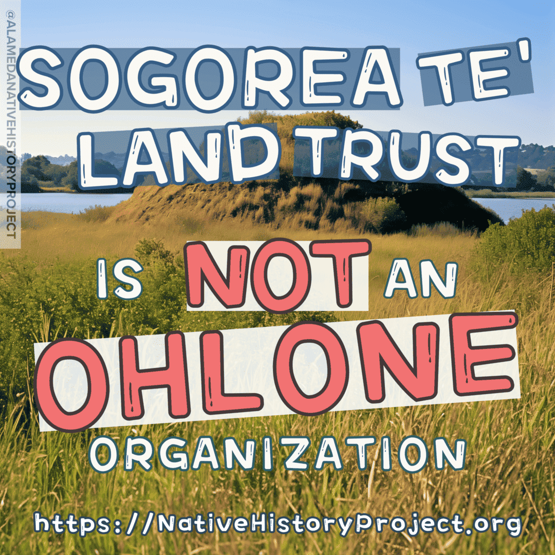
Sogorea Te Land Trust is a non-profit Land Trust that’s supposedly gathering money to purchase [Ohlone] land to return to indigenous people; support “rematriation”; and create urban gardens, and community centers.
However….
Not the Yocha Dehe Wintun Tribe, Wintu Tribe of Northern California, Muwekma Ohlone Tribe of the San Francisco, or the Costanoan Rumsen Carmel Tribe, just to name a few.
The only group benefitting from the Sogorea Te Land Trust’s work seems to be a corporation posing as a Tribal Government, the Confederated Villages of the Lisjan Nation, INC.
But the fact that:
Means that the Sogorea Te Land is getting closer and closer to impersonating a tribe, or at least benefitting from the false impression that the Land Trust is an Ohlone Tribe or Ohlone Tribal Organization–which it is not.
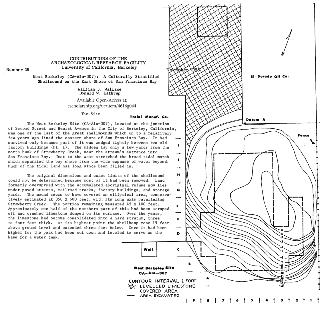
The West Berkeley Shellmound has been declared “one of the most endangered historic places” in the U.S. But it’s a parking lot.
Out of the over 425 historic shellmounds in the San Francisco Bay Area, the Berkeley Shellmound doesn’t even make the list of “endangered places” when you compare it to the shellmounds actively being quarried in San Rafael and Richmond.
I would argue: the only reason the West Berkeley Shellmound has received so much attention is because it’s a flat, empty space which is easy to fit a hundred protestors on top of. [Other shellmounds are behind fences, and protected by Oil, Quarry and Other Industries’ Private Security Companies.]
But, as a sacred site that needs protecting, the West Berkeley Shellmound is at the bottom of the list–mostly because it’s already 👏🏽 been 👏🏽 destroyed 👏🏽; and, also, because the Spenger’s Parking Lot is not where the shellmound used to be.
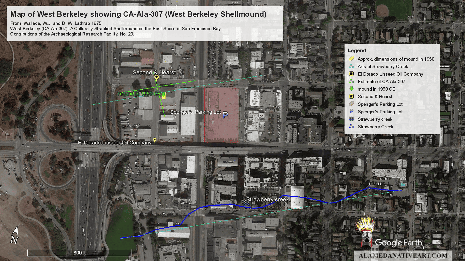
The historic location of the West Berkeley Shellmound is on the other side of the train tracks, under what’s now mostly a Truitt & White Lumber Yard.
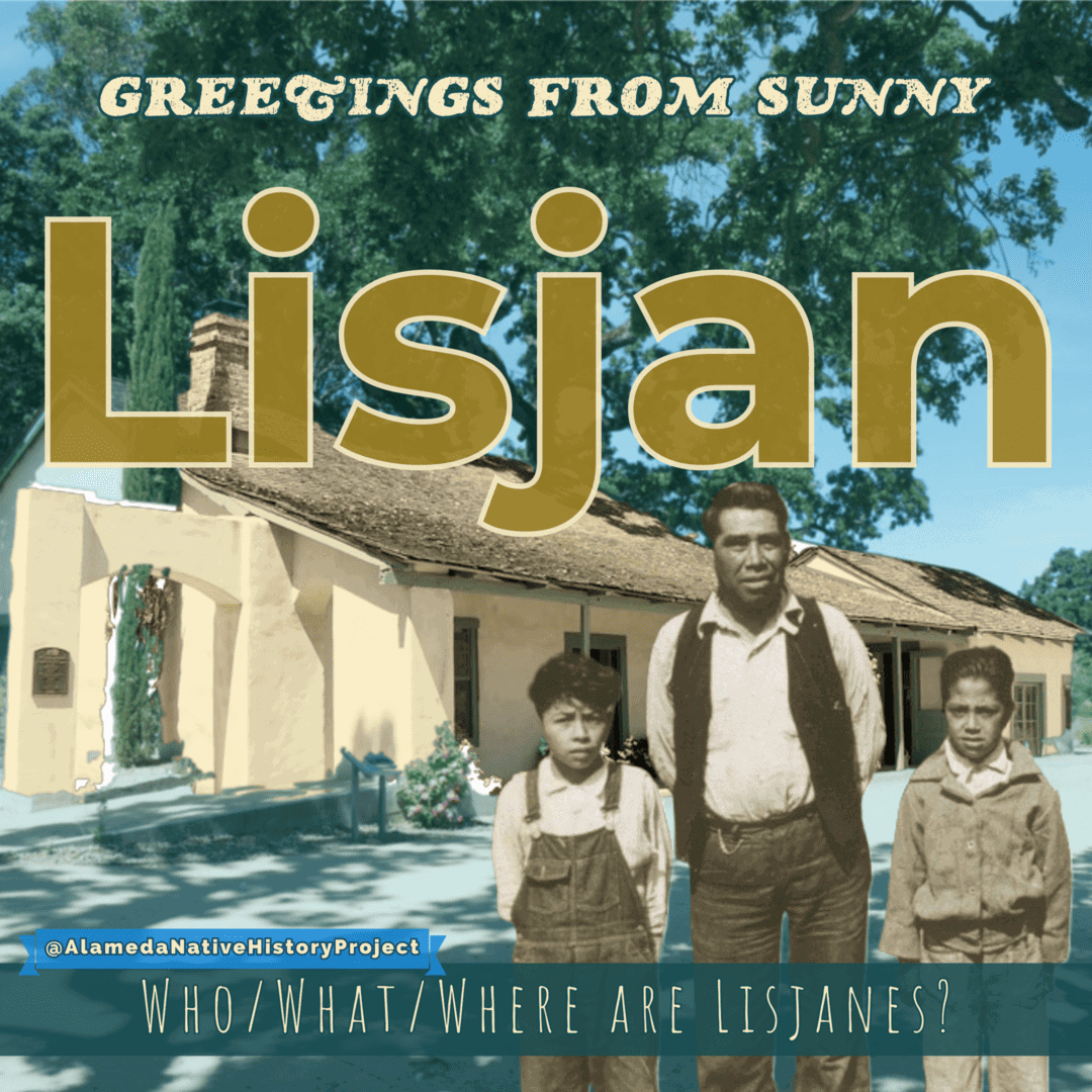
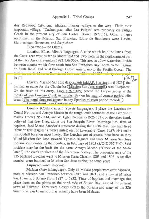
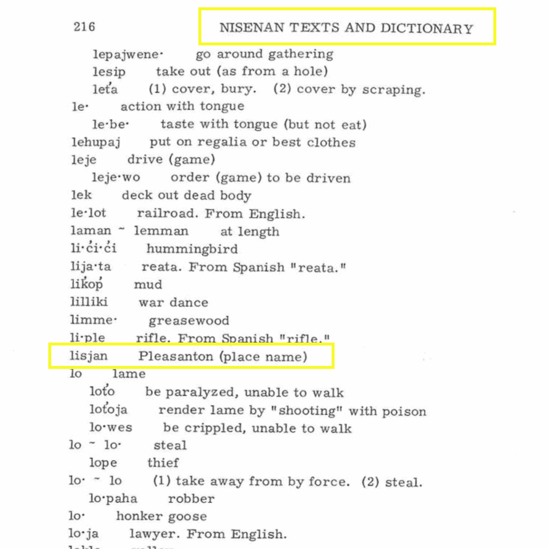
Lisjan (or “lisyan”) does not appear in any historic mission records–or anywhere else–until 1921: when a Muwekma Ohlone ancestor (Jose Guzman) said “Yo soy lisjanes“, to define himself as someone from the Bernal, and Alisal Rancherias, in what’s known as Pleasanton today.
Aside from the fact that “Lisjan” appears in an interview of Muwekma ancestor Jose Guzman, which occurred about 87 years after the secularization of the Missions in California: there is nothing to prove that an Ohlone village named Lisjan ever existed. In fact, the only thing passages referring to “Lisjan” prove is that “Lisjan” is the place name for Pleasanton, California; not East Oakland–where Corrina Gould claims the “Lisjan” homeland is.
To dive in deeper to the references of “Lisjan” in the 1921 interview of Jose Guzman: Guzman was busy discussing how his family came from the North–which was Nisenan territory, where the word “Lisjan” came from–to Pleasanton. In this passage, Guzman talked about his family’s history, and of his grandfather speaking Russian.

Corporations can never be tribes.
Especially non-profit corporations.
Tribes can create corporations through State Law (State-Chartered Corporation), through Tribal Law (Tribally Chartered Corporation), or through Section 17 of the Indian Reorganization Act of 1934.
But Corporations are not Tribal Governments, because Tribal Governments are Sovereign Nations which exist outside of the normal U.S. Corporate Structure.
The Muwekma Ohlone Tribe is comprised of all the remaining known Indian lineages who survived the California Missions. They have over 614 enrolled tribal members.
The reason why the Muwekma Ohlone tribe seems like it’s “The San Jose Tribe”, or is only in Santa Clara is because Mission San Jose was down in Fremont. That’s where all the “Indians” got let out from when the Mission systems closed down. So that’s why the Governor issued an order re: squatters on Mission Lands; and why the present-day Muwekma population is distributed the way it is. [That is a completely different historical topic for another day.]
“But we have members all over the Bay Area,” Muwekma Chairwoman Charlene Nijmeh told me. This includes places outside of San Jose, like Castro Valley, Oakland, Berkeley, San Francisco–and even in Manteca, and Sacramento, and beyond.
When you look closer, the “tribe” Corrina Gould purports to represent is comprised only of her own immediate family members.
The pictures of the Confederated Villages of the Lisjan Nation, INC. usually have 5 or 6 actual Ohlone descendants, and the rest of the crew is comprised of Gould’s non-indigenous (“white”) supporters–who are no more Tribal Members than Ward Churchill or Elizabeth Hoover.
If Corrina Gould were really trying to educate the public, she would have told you the truth a long time ago, and actually stepped aside to let the real tribe she came from benefit from the work she purports to do “for Ohlone people”–instead of doing it for her personal benefit, and the benefit of her immediate family members.
We get it, you feel guilty about what your ancestors did Native Americans.
Which leads me to this last point….